IMAGES TAKEN NEAR TO
Halls Hill, GRANTHAM, NG31 7TP
Introduction
This page details the photographs taken nearby to Halls Hill, NG31 7TP by members of the Geograph project.
The Geograph project started in 2005 with the aim of publishing, organising and preserving representative images for every square kilometre of Great Britain, Ireland and the Isle of Man.

There are currently over 7.5m images from over14,400 individuals and you can help contribute to the project by visiting https://www.geograph.org.uk
Image Map
Images are licensed for reuse under creativecommons.org/licenses/by-sa/2.0
Notes
- Clicking on the map will re-center to the selected point.
- The higher the marker number, the further away the image location is from the centre of the postcode.
Image Listing (6 Images Found)
Images are licensed for reuse under creativecommons.org/licenses/by-sa/2.0
Image
Details
Distance
1
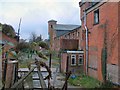
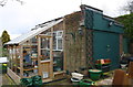
Disused malthouse
Disused malthouse at Grantham
Image: © Steve Edge
Taken: 2 Dec 2005
0.12 miles
4
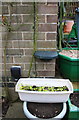
Benchmark on garage at rear of #2 Kenwick Drive
Ordnance Survey cut mark benchmark described on the Bench Mark Database at http://www.bench-marks.org.uk/bm74699
Image: © Roger Templeman
Taken: 7 Apr 2016
0.17 miles
5
Garage at rear of #2 Kenwick Drive
There is an OS benchmark Image on the near corner, left hand face, of the garage
Image: © Roger Templeman
Taken: 7 Apr 2016
0.17 miles
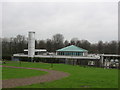
6
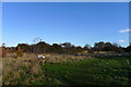
Hills and Hollows Wildlife Area, Hall's Hill, Grantham
The Parish Council of Londonthorpe and Harrowby Without fought hard to protect this land from other development https://londonthorpe-harrowby-without.parish.lincolnshire.gov.uk/parish-information/hills-hollows/1
Image: © Tim Heaton
Taken: 19 Nov 2021
0.25 miles