IMAGES TAKEN NEAR TO
Bridge End Grove, GRANTHAM, NG31 7HN
Introduction
This page details the photographs taken nearby to Bridge End Grove, NG31 7HN by members of the Geograph project.
The Geograph project started in 2005 with the aim of publishing, organising and preserving representative images for every square kilometre of Great Britain, Ireland and the Isle of Man.

There are currently over 7.5m images from over14,400 individuals and you can help contribute to the project by visiting https://www.geograph.org.uk
Image Map
Images are licensed for reuse under creativecommons.org/licenses/by-sa/2.0
Notes
- Clicking on the map will re-center to the selected point.
- The higher the marker number, the further away the image location is from the centre of the postcode.
Image Listing (2 Images Found)
Images are licensed for reuse under creativecommons.org/licenses/by-sa/2.0
Image
Details
Distance
1
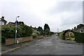
Saltersford Road, Grantham
Shown on the 1886 OS map as an isolated short lane running south; presumably towards Salter's Ford on the River Witham.
Image: © Tim Heaton
Taken: 31 Aug 2021
0.11 miles
2
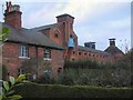
Cottages and old malthouse
Cottages and old malthouse at Grantham
Image: © Steve Edge
Taken: 2 Dec 2005
0.14 miles