IMAGES TAKEN NEAR TO
Botany Close, NOTTINGHAM, NG2 7TG
Introduction
This page details the photographs taken nearby to Botany Close, NG2 7TG by members of the Geograph project.
The Geograph project started in 2005 with the aim of publishing, organising and preserving representative images for every square kilometre of Great Britain, Ireland and the Isle of Man.

There are currently over 7.5m images from over14,400 individuals and you can help contribute to the project by visiting https://www.geograph.org.uk
Image Map
Images are licensed for reuse under creativecommons.org/licenses/by-sa/2.0
Notes
- Clicking on the map will re-center to the selected point.
- The higher the marker number, the further away the image location is from the centre of the postcode.
Image Listing (15 Images Found)
Images are licensed for reuse under creativecommons.org/licenses/by-sa/2.0
Image
Details
Distance
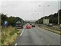
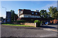
3

Landmere Lane
Heading into Wilford from the A52.
Image: © David Lally
Taken: 22 Jan 2009
0.13 miles
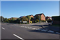
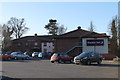
5
The Nottingham Knight Premier Lodge
On the southern outskirts of the city adjacent to the A52.
Image: © David Lally
Taken: 22 Jan 2009
0.19 miles
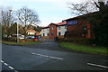
8
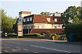
The Nottingham Knight, Compton Acres
A very nice art deco example with all its original windows.
Image: © David Howard
Taken: 8 May 2022
0.22 miles
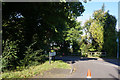
10
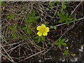
Common Cinquefoil (potentilla reptans)
A typical flower of roadside verges, as here along Wilford Road. The name ('five leaves') derives from the distinctive 5-lobed leaves clearly visible in this image.
Image: © Alan Murray-Rust
Taken: 27 Jun 2012
0.22 miles