IMAGES TAKEN NEAR TO
Acorn Bank, NOTTINGHAM, NG2 7SH
Introduction
This page details the photographs taken nearby to Acorn Bank, NG2 7SH by members of the Geograph project.
The Geograph project started in 2005 with the aim of publishing, organising and preserving representative images for every square kilometre of Great Britain, Ireland and the Isle of Man.

There are currently over 7.5m images from over14,400 individuals and you can help contribute to the project by visiting https://www.geograph.org.uk
Image Map
Images are licensed for reuse under creativecommons.org/licenses/by-sa/2.0
Notes
- Clicking on the map will re-center to the selected point.
- The higher the marker number, the further away the image location is from the centre of the postcode.
Image Listing (66 Images Found)
Images are licensed for reuse under creativecommons.org/licenses/by-sa/2.0
Image
Details
Distance
1
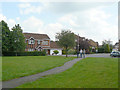
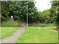
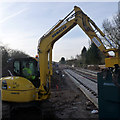
Acorn Bank
Cul-de-sac off Compton Acres; the footpath leads onto the old railway alignment.
Image: © Alan Murray-Rust
Taken: 29 May 2009
0.03 miles
2
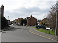
West Bridgford - Acorn Bank
Taken at the junction with Killerton Park Drive.
Image: © Peter Whatley
Taken: 22 Mar 2009
0.05 miles
3
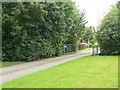
Footpath and cycleway
At Ascott Gardens; the path leads through to Ruddington Lane.
Image: © Alan Murray-Rust
Taken: 29 May 2009
0.06 miles
4
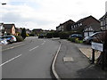
West Bridgford - Killerton Park Drive
Image: © Peter Whatley
Taken: 22 Mar 2009
0.06 miles
5
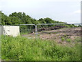
Footpath onto the old railway at Acorn Bank
The railway will become the route of the proposed tramway extension to Clifton. The embankment will be removed, with the tram running at ground level. A new bridge or culvert over the land drain will be required to replace the one visible here.
Image: © Alan Murray-Rust
Taken: 29 May 2009
0.07 miles
6
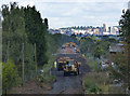
Clearing the embankment
Telephote view looking north from Ruddington Lane along the former railway embankment. Spoil is being moved from here to the new alignment towards Clifton Estate http://www.geograph.org.uk/photo/3140181.
Image: © Alan Murray-Rust
Taken: 19 Sep 2012
0.07 miles
7
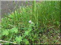
Dovesfoot Cranesbill (Geranium molle)
On the footpath along the old railway alignment.
Image: © Alan Murray-Rust
Taken: 29 May 2009
0.07 miles
8
Compton Acres tram stop
Shelters are in place. The overhead is in course of erection.
Image: © Alan Murray-Rust
Taken: 8 Sep 2014
0.08 miles
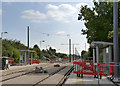
9
Ruddington Lane tram stop
The tracks are now in situ, laid in concrete at the stop itself and on sleepers for the remainder.
Image: © Alan Murray-Rust
Taken: 3 Feb 2014
0.08 miles
10
Compton Acres tram stop site
More active work is due to commence here shortly.
Image: © Alan Murray-Rust
Taken: 27 Jun 2012
0.08 miles