IMAGES TAKEN NEAR TO
William Road, NOTTINGHAM, NG2 7QD
Introduction
This page details the photographs taken nearby to William Road, NG2 7QD by members of the Geograph project.
The Geograph project started in 2005 with the aim of publishing, organising and preserving representative images for every square kilometre of Great Britain, Ireland and the Isle of Man.

There are currently over 7.5m images from over14,400 individuals and you can help contribute to the project by visiting https://www.geograph.org.uk
Image Map
Images are licensed for reuse under creativecommons.org/licenses/by-sa/2.0
Notes
- Clicking on the map will re-center to the selected point.
- The higher the marker number, the further away the image location is from the centre of the postcode.
Image Listing (417 Images Found)
Images are licensed for reuse under creativecommons.org/licenses/by-sa/2.0
Image
Details
Distance
1
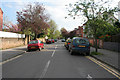
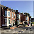
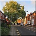
William Road, West Bridgford
A street of late Victorian semi-detached villas, many now used as student lets.
View from the junction with Millicent Road.
Image: © Kate Jewell
Taken: 22 Apr 2009
0.02 miles
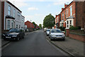
2
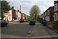
William Road, West Bridgford
Half way down this street of late Victorian semi-detached villas, many now used as student lets.
Image: © Kate Jewell
Taken: 22 Apr 2009
0.02 miles
3
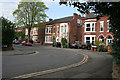
A bend in the road
This is where Patrick Road turns into William Road. Photograph taken from the end of Epperstone Road.
Image: © Kate Jewell
Taken: 22 Apr 2009
0.04 miles
4
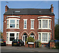
William Road, West Bridgford
A pair of late Victorian semi-detached villas on the corner with Patrick Road.
Image: © Kate Jewell
Taken: 22 Apr 2009
0.05 miles
5
West Bridgford: morning sunlight, Patrick Road
These typical Bridgford villas are near the corners of Epperstone Road and William Road.
Image: © John Sutton
Taken: 18 Sep 2019
0.05 miles
6
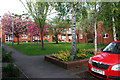
Church Croft, West Bridgford
A modern sheltered housing development with retirement flats, houses and large community centre off Stratford Road. The development includes this tree shaded green and plenty of benches to sit and chat. See also http://www.geograph.org.uk/photo/1270161
Image: © Kate Jewell
Taken: 22 Apr 2009
0.05 miles
7
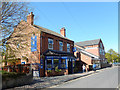
The Stratford Haven, West Bridgford
This pub on Stratford Road was converted from a pet shop by the Castle Rock Brewery in 1999.
Image: © Stephen McKay
Taken: 18 Apr 2015
0.06 miles
8
West Bridgford: The Stratford Haven
There were very few licensed premises in the centre of strait-laced Bridgford when I was young. The Stratford Haven opened as a pub in 1999.
Image: © John Sutton
Taken: 19 Apr 2019
0.06 miles
9
Stratford Road on a September evening
Looking towards Bridgford Road and the Co-op on a late-summer evening.
Image: © John Sutton
Taken: 6 Sep 2018
0.06 miles
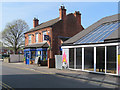
10
Stratford Road, West Bridgford
Looking towards Bridgford Road. Victorian terraced housing on the right and a modern housing scheme with flats and houses on the far left. See http://www.geograph.org.uk/photo/1269539 http://www.geograph.org.uk/photo/1270161 and http://www.geograph.org.uk/photo/1267726
During the fast growth of Nottingham in the Victorian period pressure was put on the Musters Family, who owned much of the land in West Bridgford, to allow suburban development south of the River Trent. Eventually the Musters sold their land, but they put in place strict planning regulations to the area then known as the West Bridgford Estate. This development was planned over a grid of tree lined streets. The main roads such as Musters Road (see Image) had restrictions on the density of housing and house size. Smaller houses were permitted on side streets, and terraces were erected on roads such as Stratford Road for the servants of the wealthy Nottingham merchants who bought up the larger properties.
It is interesting to note that there are no "Streets" in West Bridgford. Originally many roads were name "Street" but this was felt to be too urban by the Victorian "planners". Thus all street names were changed from "Street" to "Road". The one exception is "Village Street" in Edwalton, a village that has been totally absorbed into the town of West Bridgford.
Image: © Kate Jewell
Taken: 22 Apr 2009
0.06 miles