IMAGES TAKEN NEAR TO
Millicent Grove, NOTTINGHAM, NG2 7QB
Introduction
This page details the photographs taken nearby to Millicent Grove, NG2 7QB by members of the Geograph project.
The Geograph project started in 2005 with the aim of publishing, organising and preserving representative images for every square kilometre of Great Britain, Ireland and the Isle of Man.

There are currently over 7.5m images from over14,400 individuals and you can help contribute to the project by visiting https://www.geograph.org.uk
Image Map
Images are licensed for reuse under creativecommons.org/licenses/by-sa/2.0
Notes
- Clicking on the map will re-center to the selected point.
- The higher the marker number, the further away the image location is from the centre of the postcode.
Image Listing (456 Images Found)
Images are licensed for reuse under creativecommons.org/licenses/by-sa/2.0
Image
Details
Distance
1
Once a main line to London
Fast trains from Nottingham (Midland) to St Pancras once took the Melton Direct Line, which crossed the Trent on what is now Lady Bay Road bridge and passed through the middle of Bridgford on its way to Melton, then Oakham and Kettering. The embankment slopes down to where the long-gone bridge crossed Bridgford Road. The newish red brick building in the centre is one of many built on the site of the levelled embankment from here to Melton Road. Other pictures nearby, including Image] and Image], show railway remains in Bridgford.
Image: © John Sutton
Taken: 19 Apr 2015
0.03 miles
2
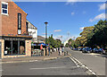
West Bridgford: at the corner of Stratford Road
Looking along Bridgford Road towards three of the floodlights at Trent Bridge Cricket Ground.
Image: © John Sutton
Taken: 5 Sep 2022
0.04 miles
3
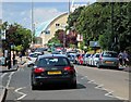
A good crowd on Bridgford Road
Some of a crowd of over 11,000 making their way along Bridgford Road to Trent Bridge Cricket Ground for the Twenty20 quarter final between Nottinghamshire and Hampshire. Notts partisans were in for yet another disappointment - a fourth consecutive quarter-final defeat.
Image: © John Sutton
Taken: 3 Aug 2014
0.04 miles
4
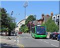
West Bridgford: the Bingham bus
The V1 service to Bingham and East Bridgford on Bridgford Road. The floodlights of Trent Bridge Cricket Ground show against a cloudless sky.
Image: © John Sutton
Taken: 28 Jun 2018
0.05 miles
5
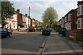
William Road, West Bridgford
A street of late Victorian semi-detached villas, many now used as student lets.
View from the junction with Millicent Road.
Image: © Kate Jewell
Taken: 22 Apr 2009
0.05 miles
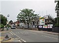
6
West Bridgford: The Stratford Haven
There were very few licensed premises in the centre of strait-laced Bridgford when I was young. The Stratford Haven opened as a pub in 1999.
Image: © John Sutton
Taken: 19 Apr 2019
0.05 miles
7
Bridgford Road: new flats
A new block, replacing a large Victorian house, is being built on a wedge of land west of the former Midland Railway embankment. One of the floodlights of Trent Bridge Cricket Ground shows on the left.
Image: © John Sutton
Taken: 23 Aug 2013
0.05 miles
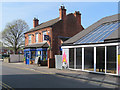
8
The Stratford Haven, West Bridgford
This pub on Stratford Road was converted from a pet shop by the Castle Rock Brewery in 1999.
Image: © Stephen McKay
Taken: 18 Apr 2015
0.05 miles
9
William Road, West Bridgford
Half way down this street of late Victorian semi-detached villas, many now used as student lets.
Image: © Kate Jewell
Taken: 22 Apr 2009
0.06 miles
10
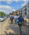
Bridgford Road: on the way to the 2014 Test Match
Cricket enthusiasts on their way to Trent Bridge on the first day of the First Test Match between England and India on a sunny July morning. The new flats on the right are nearly complete. For comparison, see Image] and Image
Image: © John Sutton
Taken: 9 Jul 2014
0.06 miles