IMAGES TAKEN NEAR TO
Melton Road, NOTTINGHAM, NG2 7NF
Introduction
This page details the photographs taken nearby to Melton Road, NG2 7NF by members of the Geograph project.
The Geograph project started in 2005 with the aim of publishing, organising and preserving representative images for every square kilometre of Great Britain, Ireland and the Isle of Man.

There are currently over 7.5m images from over14,400 individuals and you can help contribute to the project by visiting https://www.geograph.org.uk
Image Map (Loading...)


Getting Data...Please wait
Leaflet Map data © OpenStreetMap
Images are licensed for reuse under creativecommons.org/licenses/by-sa/2.0
Notes
- Clicking on the map will re-center to the selected point.
- The higher the marker number, the further away the image location is from the centre of the postcode.
Image Listing (81 Images Found)
Images are licensed for reuse under creativecommons.org/licenses/by-sa/2.0
Image
Details
Distance
1
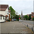
West Bridgford: Rufford Court, Melton Road
Rufford Court is divided into flats. West Bridgford Baptist Church is further along, at the Musters Road crossroads.
Image: © John Sutton
Taken: 22 May 2021
0.01 miles
2
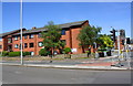
Peveril Court, Melton Road
Modern housing where there was a toll house in 1840 - see www.bench-marks.org.uk/bm20195 for additional information
Image: © Roger Templeman
Taken: 14 May 2018
0.03 miles
3
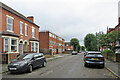
West Bridgford: on North Road
This part of Bridgford dates mostly from the late Victorian and Edwardian periods. I imagine the Serina Court flats may have been built in the 1960s.
Image: © John Sutton
Taken: 27 Jul 2023
0.05 miles
4
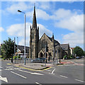
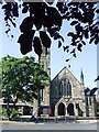
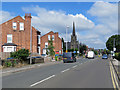
West Bridgford Baptist Church
The church is at the junction of Melton Road and Musters Road. Its website explains that "A building committee was created and the stone-laying ceremony took place on 17 January 1907. The building of the church took 9 months and the official opening was on 26 September 1907. The adjoining halls were added later and the buildings were electrified in 1930".
Image: © John Sutton
Taken: 15 Jul 2019
0.05 miles
6
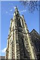
The tower and spire of West Bridgford Baptist Church
The spire is an Ordnance Survey intersected station trig point, http://www.trigpointinguk.com/trigs/trig-details.php?t=11460
Image: © Roger Templeman
Taken: 3 Apr 2013
0.05 miles
7
West Bridgford: Carlyle Road
Carlyle Road runs from Melton Road (just behind the camera) to Loughborough Road.
Image: © John Sutton
Taken: 26 Sep 2018
0.05 miles
8
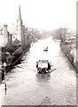
Melton Road in the floods of March 1947
The photo, from the family albums, is taken from the railway bridge, looking towards West Bridgford Baptist Church and the junction with Musters Road (just behind the second lorry). Whether this photo was taken by an adventurous Auntie Gladys, whose writing on the back dates the picture, I don't know. My mother's family lived just south of here, in Manvers Road, which was also flooded.
Image: © Not known (family album)
Taken: 18 Mar 1947
0.05 miles
9
West Bridgford: on Melton Road
This picture was taken from where, until it closed in 1968, the Nottingham to Melton Mowbray railway line crossed Melton Road. It may be interesting to compare this picture with Image
Image: © John Sutton
Taken: 15 Jul 2019
0.08 miles
10
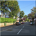
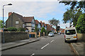
West Bridgford: along Henry Road
The Melton Road end of a long, straight road of prosperous-looking Victorian villas, photographed on a bright September morning.
Image: © John Sutton
Taken: 19 Sep 2019
0.08 miles