IMAGES TAKEN NEAR TO
Rushworth Avenue, NOTTINGHAM, NG2 7LF
Introduction
This page details the photographs taken nearby to Rushworth Avenue, NG2 7LF by members of the Geograph project.
The Geograph project started in 2005 with the aim of publishing, organising and preserving representative images for every square kilometre of Great Britain, Ireland and the Isle of Man.

There are currently over 7.5m images from over14,400 individuals and you can help contribute to the project by visiting https://www.geograph.org.uk
Image Map (Loading...)


Getting Data...Please wait
Leaflet Map data © OpenStreetMap
Images are licensed for reuse under creativecommons.org/licenses/by-sa/2.0
Notes
- Clicking on the map will re-center to the selected point.
- The higher the marker number, the further away the image location is from the centre of the postcode.
Image Listing (656 Images Found)
Images are licensed for reuse under creativecommons.org/licenses/by-sa/2.0
Image
Details
Distance
1
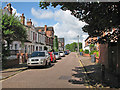
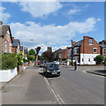
West Bridgford: Rushworth Avenue
The white terrace with pediments is unlike other houses in Victorian and Edwardian Bridgford - I have a feeling that it may be slightly earlier than most of them. The view is from the corner of Musters Road, looking towards Loughborough Road.
Image: © John Sutton
Taken: 3 Jul 2016
0.00 miles
2
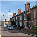
West Bridgford: Bridge Grove
Victorian houses between Loughborough Road and Musters Road, with two of the floodlights at Trent Bridge Cricket Ground in the middle distance.
Image: © John Sutton
Taken: 13 Aug 2016
0.03 miles
3
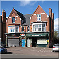
Shops on Musters Road
The Victorian shop fronts have green and brown glazed tiles, and I imagine both gables were originally like the one on the left. PCRC specialises in laptop and phone repairs. Mrs Bunns is a Cob Emporium (cobs are round bread rolls in Nottingham and some other places).
Image: © John Sutton
Taken: 10 Apr 2016
0.04 miles
4
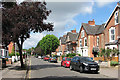
Millicent Road
Solid Victorian villas on each side.
Image: © John Sutton
Taken: 17 Jul 2016
0.04 miles
5
West Bridgford: on Millicent Road
Looking towards Musters Road and Friary United Reformed Church from near the corner of Henry Road.
Image: © John Sutton
Taken: 12 May 2019
0.04 miles
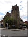
7
West Bridgford: Friary United Reformed Church
The former Congregational Church (1901) stands at the corner of Millicent Road and Musters Road. Image] shows the Musters Road side on a sunnier day than this one.
Image: © John Sutton
Taken: 27 Sep 2022
0.05 miles
8
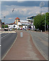
West Bridgford: on Loughborough Road
Looking towards Trent Bridge Cricket Ground from the pedestrian crossing at the end of Millicent Road. (The picture was taken during the interval of a One-Day Cup semi-final, so there were fewer spectators on the Radcliffe Road middle tier than during play - like me, many of them had left their seats to stretch their legs.)
Image: © John Sutton
Taken: 12 May 2019
0.05 miles
9
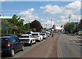
Queuing traffic on Loughborough Road
Trent Bridge was closed on a Sunday morning because of the Asda Foundation ten-kilometre charity run, so cars were queuing to turn towards Lady Bay Bridge. On the top tier of the Radcliffe Road End of Trent Bridge Cricket Ground some spectators had arrived early for the start of a County Championship match.
Image: © John Sutton
Taken: 15 May 2016
0.05 miles
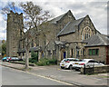
10
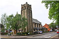
Friary United Reformed Church, Millicent Road
There is an OS benchmark Image on the road face of the right hand buttress on the near corner of the church's tower
Image: © Roger Templeman
Taken: 12 May 2018
0.05 miles