IMAGES TAKEN NEAR TO
Mickleborough Way, NOTTINGHAM, NG2 7HF
Introduction
This page details the photographs taken nearby to Mickleborough Way, NG2 7HF by members of the Geograph project.
The Geograph project started in 2005 with the aim of publishing, organising and preserving representative images for every square kilometre of Great Britain, Ireland and the Isle of Man.

There are currently over 7.5m images from over14,400 individuals and you can help contribute to the project by visiting https://www.geograph.org.uk
Image Map
Images are licensed for reuse under creativecommons.org/licenses/by-sa/2.0
Notes
- Clicking on the map will re-center to the selected point.
- The higher the marker number, the further away the image location is from the centre of the postcode.
Image Listing (20 Images Found)
Images are licensed for reuse under creativecommons.org/licenses/by-sa/2.0
Image
Details
Distance
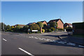
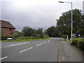
1
Mickleborough Way, Compton Acres
Mickleborough Way links Compton Acres estate with the earlier Wolds Estate development.
Image: © Richard Vince
Taken: 1 Sep 2012
0.02 miles
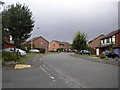
2
Footpath off Mickleborough Way
One of the many short footpaths which connect closes in the Compton Acres development.
Image: © Alan Murray-Rust
Taken: 10 Oct 2021
0.07 miles
3
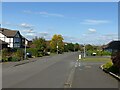
Walcote Drive, Wolds Estate
Walcote Drive was the outer edge of the Wolds Estate, developed in the 1960s and 1970s, but then only had houses on one side – the right as seen here. With the development of Compton Acres in the 1980s, houses appeared on the left hand side as well.
Image: © Alan Murray-Rust
Taken: 10 Oct 2021
0.10 miles
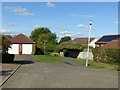
4
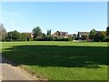
Open space in Compton Acres
Compton Acres is a large housing development from the 1980s and includes a number of similar small green spaces together with an intricate network of footpaths.
Image: © Alan Murray-Rust
Taken: 10 Oct 2021
0.11 miles
5
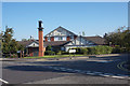
The Apple Tree public house
Compton Acres, West Bridgford.
Image: © Ian S
Taken: 31 Aug 2020
0.13 miles
6
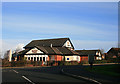
The Apple Tree
Quite modern "estate" pub. Probably 10 to 20 years old, like most of the surrounding houses.
Image: © David Lally
Taken: 22 Jan 2009
0.14 miles
7

The Apple Tree public house
Compton Acres, West Bridgford.
Image: © Ian S
Taken: 31 Aug 2020
0.15 miles
8
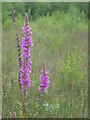
Purple Loosestrife at Wilford claypit
Image: © David Vaughan-Birch
Taken: 8 Aug 2007
0.15 miles
9
North end of Landmere Lane, West Bridgford
North of the junction with Stonesby Vale (left), Landmere Lane curves west to meet Ruddington Lane.
Image: © Richard Vince
Taken: 1 Sep 2012
0.17 miles