IMAGES TAKEN NEAR TO
Sherborne Road, NOTTINGHAM, NG2 7BN
Introduction
This page details the photographs taken nearby to Sherborne Road, NG2 7BN by members of the Geograph project.
The Geograph project started in 2005 with the aim of publishing, organising and preserving representative images for every square kilometre of Great Britain, Ireland and the Isle of Man.

There are currently over 7.5m images from over14,400 individuals and you can help contribute to the project by visiting https://www.geograph.org.uk
Image Map (Loading...)


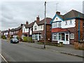
Getting Data...Please wait
Leaflet Map data © OpenStreetMap
Images are licensed for reuse under creativecommons.org/licenses/by-sa/2.0
Notes
- Clicking on the map will re-center to the selected point.
- The higher the marker number, the further away the image location is from the centre of the postcode.
Image Listing (22 Images Found)
Images are licensed for reuse under creativecommons.org/licenses/by-sa/2.0
Image
Details
Distance
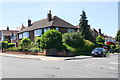
1

Musters Road, West Bridgford
This runs in a straight line down to Trent Bridge Cricket Ground.
Image: © Alan Murray-Rust
Taken: 20 Feb 2017
0.07 miles

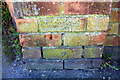
3
Bench mark, Malvern Road, West Bridgford
See http://www.geograph.org.uk/photo/5291015 for location.
Image: © Alan Murray-Rust
Taken: 20 Feb 2017
0.11 miles
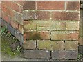
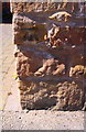
4
Benchmark on wall pier on south side Malvern Road
Ordnance Survey cut mark benchmark described on the Bench Mark Database at https://www.bench-marks.org.uk/bm82486
Image: © Roger Templeman
Taken: 14 May 2018
0.11 miles
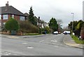
5
#280 Musters Road at Malvern Road junction
There is an OS benchmark Image on the brick wall pier right of the cabinet on the pavement at the corner
Image: © Roger Templeman
Taken: 14 May 2018
0.11 miles
6
Malvern Road, West Bridgford
There is a bench mark http://www.geograph.org.uk/photo/5291013 on the brick pier to the right of the junction box on the left hand corner of the junction.
Image: © Alan Murray-Rust
Taken: 20 Feb 2017
0.12 miles
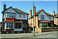
7
Selby Road, West Bridgford
Typical of this extensive development of inter-war housing. There is a bench mark http://www.geograph.org.uk/photo/5291039 on the stone pier at the right hand side of the picture.
Image: © Alan Murray-Rust
Taken: 20 Feb 2017
0.17 miles
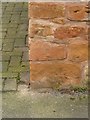
8
Benchmark on wall corner outside #16 Selby Road
Ordnance Survey cut mark benchmark described on the Bench Mark Database at https://www.bench-marks.org.uk/bm82483
Image: © Roger Templeman
Taken: 14 May 2018
0.18 miles
9
Bench mark, 16 Selby Road, West Bridgford
See http://www.geograph.org.uk/photo/5291042 for location.
Image: © Alan Murray-Rust
Taken: 20 Feb 2017
0.18 miles
10
Nos. 16 and 18 Selby Road
There is an OS benchmark Image on the corner, road face, of the wall in front of the right hand house
Image: © Roger Templeman
Taken: 14 May 2018
0.18 miles