IMAGES TAKEN NEAR TO
Melton Road, NOTTINGHAM, NG2 6UF
Introduction
This page details the photographs taken nearby to Melton Road, NG2 6UF by members of the Geograph project.
The Geograph project started in 2005 with the aim of publishing, organising and preserving representative images for every square kilometre of Great Britain, Ireland and the Isle of Man.

There are currently over 7.5m images from over14,400 individuals and you can help contribute to the project by visiting https://www.geograph.org.uk
Image Map
Images are licensed for reuse under creativecommons.org/licenses/by-sa/2.0
Notes
- Clicking on the map will re-center to the selected point.
- The higher the marker number, the further away the image location is from the centre of the postcode.
Image Listing (88 Images Found)
Images are licensed for reuse under creativecommons.org/licenses/by-sa/2.0
Image
Details
Distance
1
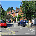
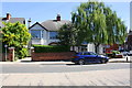
West Bridgford: Haddon Road
A cul de sac of typical Bridgford villas off Melton Road.
Image: © John Sutton
Taken: 3 Jul 2019
0.04 miles
2
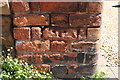
Benchmark on brick gatepost of 89a Melton Road
Ordnance Survey cut mark benchmark levelled at 25.201m above Newlyn Datum with additional information to be found on the Bench Mark Database at www.bench-marks.org.uk/bm112894
Image: © Roger Templeman
Taken: 14 May 2018
0.04 miles
3
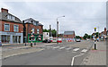
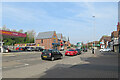
Changes on Melton Road
The Esso garage has been demolished and will be replaced by a Sainsbury's Local and petrol station. There was not much traffic on Bank Holiday Sunday morning.
Image: © John Sutton
Taken: 28 May 2017
0.04 miles
4
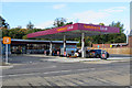
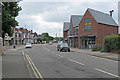
West Bridgford: Sainsbury's Local, Melton Road
A recently-built filling station and convenience store. Image] gives an idea of the site in May 2017.
Image: © John Sutton
Taken: 26 Sep 2018
0.04 miles
5
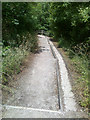
Down off the Embankment (1)
The embankment of the Midland Line running through West Bridgford is particularly steep-sided. Here the path that runs along it descends down to the level of Melton Road. This is only the first of two descents.
Image: © David Lally
Taken: 23 Jun 2009
0.05 miles
6
Nos 89a and 91 Melton Road at Clumber Road junction
There is an OS benchmark Image on the brick gatepost at the left hand side of the entrance to the left hand house
Image: © Roger Templeman
Taken: 14 May 2018
0.05 miles
7
West Bridgford: Melton Road
Easter Sunday morning.
Image: © John Sutton
Taken: 17 Apr 2022
0.05 miles
8
West Bridgford: on Melton Road
Looking towards the shops and Edwalton from where, until 1968, the Nottingham-Melton-St Pancras railway line crossed on a tall bridge.
Image: © John Sutton
Taken: 28 May 2017
0.05 miles
9
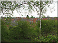
Bridgford rooftops
The rooftops of Edwardian West Bridgford are seen from the trackbed of the old Midland Railway Nottingham to Melton Mowbray line, now a footpath. Expresses reached St Pancras via Melton, Oakham, Corby and Kettering. Railway passengers would have had a clearer view as the embankment grasses were regularly mowed; the birches and bushes have grown since the line closed in the 1960s and London trains were re-routed via Loughborough and Leicester, leaving from the west end of Nottingham Station rather than the east.
Image: © John Sutton
Taken: 10 May 2010
0.05 miles
10
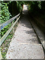
Down off the Embankment (2)
The embankment of the Midland Line running through West Bridgford is particularly steep-sided. Here the path that runs along it descends down to the level of Melton Road. This is the second of two descents.
Image: © David Lally
Taken: 23 Jun 2009
0.05 miles