IMAGES TAKEN NEAR TO
Ullscarf Close, NOTTINGHAM, NG2 6RF
Introduction
This page details the photographs taken nearby to Ullscarf Close, NG2 6RF by members of the Geograph project.
The Geograph project started in 2005 with the aim of publishing, organising and preserving representative images for every square kilometre of Great Britain, Ireland and the Isle of Man.

There are currently over 7.5m images from over14,400 individuals and you can help contribute to the project by visiting https://www.geograph.org.uk
Image Map
Images are licensed for reuse under creativecommons.org/licenses/by-sa/2.0
Notes
- Clicking on the map will re-center to the selected point.
- The higher the marker number, the further away the image location is from the centre of the postcode.
Image Listing (6 Images Found)
Images are licensed for reuse under creativecommons.org/licenses/by-sa/2.0
Image
Details
Distance
1
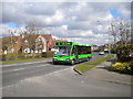
Bus on Beckside
A 5 to Nottingham city centre via Melton Road heads along Beckside past the junction with Langstrath Drive.
Image: © Richard Vince
Taken: 21 Mar 2011
0.11 miles
2
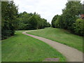
Green Corridor
Between Edwalton and Gamston
Image: © Oxymoron
Taken: 7 Aug 2008
0.16 miles
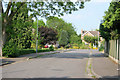
4
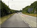
The end of Valley Road
Looking towards Valley Gardens.
Image: © Kate Jewell
Taken: 4 Jun 2010
0.22 miles
5
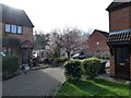
Blossom on a tree in Herons Court, Edwalton
Always nice to see any colour in Spring after a long boring and drab winter.
Image: © Jeremy Bolwell
Taken: 25 Feb 2024
0.23 miles
6
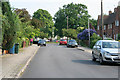
Grange Park
Grange Park turns to the right by the house at the end, which is in the next square north.
Image: © Kate Jewell
Taken: 4 Jun 2010
0.23 miles