IMAGES TAKEN NEAR TO
Ennerdale Close, NOTTINGHAM, NG2 6NG
Introduction
This page details the photographs taken nearby to Ennerdale Close, NG2 6NG by members of the Geograph project.
The Geograph project started in 2005 with the aim of publishing, organising and preserving representative images for every square kilometre of Great Britain, Ireland and the Isle of Man.

There are currently over 7.5m images from over14,400 individuals and you can help contribute to the project by visiting https://www.geograph.org.uk
Image Map
Images are licensed for reuse under creativecommons.org/licenses/by-sa/2.0
Notes
- Clicking on the map will re-center to the selected point.
- The higher the marker number, the further away the image location is from the centre of the postcode.
Image Listing (68 Images Found)
Images are licensed for reuse under creativecommons.org/licenses/by-sa/2.0
Image
Details
Distance
1
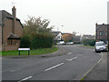
Kirkstone Drive
Typical residential road in this area of 1980s development. It links to the remains of the old hamlet of Gamston on the section of the old Tollerton Road cut off when the Lings Bar Road bypass section of the A52 was created.
Image: © Alan Murray-Rust
Taken: 13 Nov 2011
0.03 miles
2
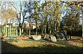
Stone circle, Gamston
Nothing ancient about this; it forms part of the Ambleside Play Park.
Image: © Alan Murray-Rust
Taken: 10 Dec 2021
0.05 miles
3

Not a Raging Bull
Timber sculpture in the Ambleside Play Park, Gamston.
Image: © Alan Murray-Rust
Taken: 10 Dec 2021
0.06 miles
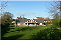
4
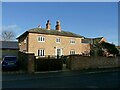
Manor Farmhouse, Gamston
An attractive early 19th century house, long divorced from any farming activity.
Image: © Alan Murray-Rust
Taken: 10 Dec 2021
0.06 miles
5

Petfood distribution centre
The only industrial site in the Gamston development of the 1990s, based on Ambleside and Beckside.
Image: © Alan Murray-Rust
Taken: 13 Nov 2011
0.08 miles
6
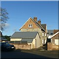
Hall Farmhouse, Gamston
Brick and stone farmhouse dating from the 18th and 19th centuries, Listed Grade II.
Image: © Alan Murray-Rust
Taken: 10 Dec 2021
0.10 miles
7
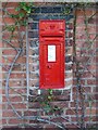
Gamston Village postbox, ref NG2 38
Standard VR wall box with wider mouth in typical projecting brickwork of the period.
Image: © Alan Murray-Rust
Taken: 10 Dec 2021
0.11 miles
8
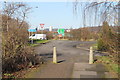
Cycle Route at the end of Old Tollerton Road
A6011 ahead.
Image: © J.Hannan-Briggs
Taken: 2 Feb 2013
0.11 miles
9
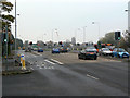
Radcliffe Road at Gamston
Formerly the A52, now the A6011, this is the main trunk road exit from Nottingham in an easterly direction.
Image: © Alan Murray-Rust
Taken: 13 Nov 2011
0.13 miles
10
Gamston Village Hall
Timber building set in an attractive green.
Image: © Alan Murray-Rust
Taken: 10 Dec 2021
0.13 miles