IMAGES TAKEN NEAR TO
Stamford Road, NOTTINGHAM, NG2 6GF
Introduction
This page details the photographs taken nearby to Stamford Road, NG2 6GF by members of the Geograph project.
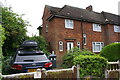
The Geograph project started in 2005 with the aim of publishing, organising and preserving representative images for every square kilometre of Great Britain, Ireland and the Isle of Man.

There are currently over 7.5m images from over14,400 individuals and you can help contribute to the project by visiting https://www.geograph.org.uk
Image Map
Images are licensed for reuse under creativecommons.org/licenses/by-sa/2.0
Notes
- Clicking on the map will re-center to the selected point.
- The higher the marker number, the further away the image location is from the centre of the postcode.
Image Listing (34 Images Found)
Images are licensed for reuse under creativecommons.org/licenses/by-sa/2.0
Image
Details
Distance
1
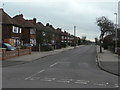
Alford Road
Looking from Stamford Road towards Edwalton.
Image: © Alan Murray-Rust
Taken: 23 Mar 2010
0.04 miles
3
Part of Stamford Road
Near Glenmore Road.
Image: © Jeremy Bolwell
Taken: 25 Feb 2024
0.05 miles
4
Covert Road
This part of West Bridgford includes substantial local authority housing development from the immediate post-WW2 era.
Image: © Alan Murray-Rust
Taken: 23 Mar 2010
0.05 miles
5
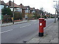
Stamford Road post-box Ref No NG2 312
Standard G VI R pillar box contemporary with its surroundings.
Image: © Alan Murray-Rust
Taken: 23 Mar 2010
0.08 miles
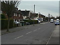
6
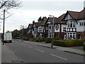
Stamford Road
Classic interwar suburbia, typical of West Bridgford's development as a dormitory suburb of Nottingham. Compare with http://www.geograph.org.uk/photo/1772587 and http://www.geograph.org.uk/photo/1772588
Image: © Alan Murray-Rust
Taken: 23 Mar 2010
0.10 miles
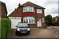
7
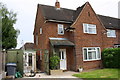
#13 Covert Road
There is an Ordnance Survey cut mark benchmark on the front of the house behind the concrete plant box. The mark is described on the Bench Mark Database at https://www.bench-marks.org.uk/bm102411
Image: © Roger Templeman
Taken: 12 May 2018
0.10 miles
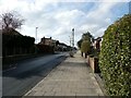
8
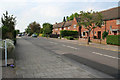
Covert Road
Looking northwards from the junction with Leahurst Road.
Image: © Kate Jewell
Taken: 4 Jun 2010
0.10 miles
9
#80 Stamford Road
There is an OS benchmark Image on the front of the house right of the wheelie bin
Image: © Roger Templeman
Taken: 12 May 2018
0.12 miles
10
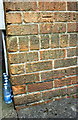
Benchmark on #80 Stamford Road
Ordnance Survey cut mark benchmark described on the Bench Mark Database at www.bench-marks.org.uk/bm102920
Image: © Roger Templeman
Taken: 12 May 2018
0.12 miles