IMAGES TAKEN NEAR TO
Haddon Road, NOTTINGHAM, NG2 6EQ
Introduction
This page details the photographs taken nearby to Haddon Road, NG2 6EQ by members of the Geograph project.
The Geograph project started in 2005 with the aim of publishing, organising and preserving representative images for every square kilometre of Great Britain, Ireland and the Isle of Man.

There are currently over 7.5m images from over14,400 individuals and you can help contribute to the project by visiting https://www.geograph.org.uk
Image Map (87 Images)


Leaflet Map data © OpenStreetMap
Images are licensed for reuse under creativecommons.org/licenses/by-sa/2.0
Notes
- Clicking on the map will re-center to the selected point.
- The higher the marker number, the further away the image location is from the centre of the postcode.
Image Listing (87 Images Found)
Images are licensed for reuse under creativecommons.org/licenses/by-sa/2.0
Image
Details
Distance
1
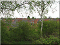
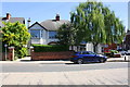
Bridgford rooftops
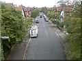
The rooftops of Edwardian West Bridgford are seen from the trackbed of the old Midland Railway Nottingham to Melton Mowbray line, now a footpath. Expresses reached St Pancras via Melton, Oakham, Corby and Kettering. Railway passengers would have had a clearer view as the embankment grasses were regularly mowed; the birches and bushes have grown since the line closed in the 1960s and London trains were re-routed via Loughborough and Leicester, leaving from the west end of Nottingham Station rather than the east.
Image: © John Sutton
Taken: 10 May 2010
0.01 miles
2
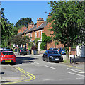
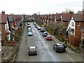
West Bridgford: Haddon Road
A cul de sac of typical Bridgford villas off Melton Road.
Image: © John Sutton
Taken: 3 Jul 2019
0.02 miles
3
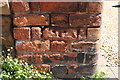
Benchmark on brick gatepost of 89a Melton Road
Ordnance Survey cut mark benchmark levelled at 25.201m above Newlyn Datum with additional information to be found on the Bench Mark Database at www.bench-marks.org.uk/bm112894
Image: © Roger Templeman
Taken: 14 May 2018
0.06 miles
4
Nos 89a and 91 Melton Road at Clumber Road junction
There is an OS benchmark Image on the brick gatepost at the left hand side of the entrance to the left hand house
Image: © Roger Templeman
Taken: 14 May 2018
0.06 miles
5
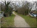
Former Midland Railway line, West Bridgford
The trackbed has been converted to a pedestrian and cycle route. This is on the bridge crossing Devonshire Road.
Image: © Alan Murray-Rust
Taken: 20 Feb 2017
0.07 miles
6
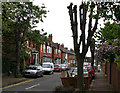
Manvers Road
The Edwardian semi on the left was one of the first houses to be built at this end of Manvers Road. My grandparents, the first occupants, moved in to No 7 (with the white slate-roofed bay window) in 1906 with their newly-born son and celebrated their golden wedding there in 1955. My mother and her two sisters were born in the front bedroom. The nice symmetry of Lonsdale Villas has been violated by the removal of the bay from No 5, alas. What would Mrs Jennings have said?
Image: © John Sutton
Taken: 10 May 2010
0.07 miles
7
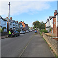
West Bridgford: Clumber Road
Looking towards Melton Road on a late-September morning.
Image: © John Sutton
Taken: 26 Sep 2018
0.08 miles
9
Devonshire Road, West Bridgford
Looking east from the old railway bridge. The housing dates from the early years of the 20th century.
Image: © Alan Murray-Rust
Taken: 20 Feb 2017
0.08 miles
10
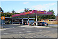
West Bridgford: Sainsbury's Local, Melton Road
A recently-built filling station and convenience store. Image] gives an idea of the site in May 2017.
Image: © John Sutton
Taken: 26 Sep 2018
0.08 miles