IMAGES TAKEN NEAR TO
Highfield Road, NOTTINGHAM, NG2 6DT
Introduction
This page details the photographs taken nearby to Highfield Road, NG2 6DT by members of the Geograph project.
The Geograph project started in 2005 with the aim of publishing, organising and preserving representative images for every square kilometre of Great Britain, Ireland and the Isle of Man.

There are currently over 7.5m images from over14,400 individuals and you can help contribute to the project by visiting https://www.geograph.org.uk
Image Map
Images are licensed for reuse under creativecommons.org/licenses/by-sa/2.0
Notes
- Clicking on the map will re-center to the selected point.
- The higher the marker number, the further away the image location is from the centre of the postcode.
Image Listing (126 Images Found)
Images are licensed for reuse under creativecommons.org/licenses/by-sa/2.0
Image
Details
Distance
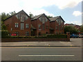
1
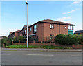
West Bridgford: where the railway used to be
Marlborough Court - retirement housing - was built in 1988 on the alignment of the former Midland Railway direct line from Nottingham to Melton, Oakham, Corby and Kettering, on which express services to St Pancras ran from 1878-1968. There was a tall embankment here and the railway crossed Melton Road on a substantial plate girder bridge. The course of the line from here to Radcliffe Road can be seen on satellite imagery as a strip of modern housing of various kinds between the Victorian and Edwardian streets which characterise the centre of Bridgford.
Image: © John Sutton
Taken: 26 Sep 2018
0.06 miles
2
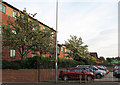
Rectory Road: where the railway once ran
West Bridgford's population rose from 293 in 1881 to 7,018 twenty years later. It is essentially a Victorian and Edwardian suburb, which is why the narrow strip of new houses running parallel to Stratford Road between Bridgford Road and Melton Road shows up so clearly on aerial photos. These flats stand where there was once a railway embankment, now levelled, which carried the Nottingham-Melton-Oakham-Corby-Kettering line on which the fastest trains from Nottingham Midland to London St Pancras ran.
Image: © John Sutton
Taken: 4 May 2011
0.06 miles
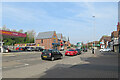
3
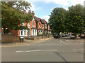
Glebe Road
At its junction with Melton Road, West Bridgford.
Image: © David Lally
Taken: 23 Jun 2009
0.07 miles
4
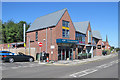
West Bridgford: The Refinery, Melton Road
A bar-restaurant next to Sainsbury's Local.
Image: © John Sutton
Taken: 3 Jul 2019
0.07 miles
6
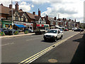
West Bridgford: Melton Road shops
Everything was quiet and closed on the morning of the May Day Bank Holiday - but there was more traffic than when my mother, who was born and grew up in nearby Manvers Road, and her sisters and friends played whip and top in dusty Melton Road in the years during and just after The Great War.
Image: © John Sutton
Taken: 2 May 2016
0.07 miles
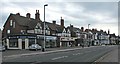
7
West Bridgford: Melton Road
Easter Sunday morning.
Image: © John Sutton
Taken: 17 Apr 2022
0.08 miles
8
West Bridgford: on Melton Road
Looking towards the shops and Edwalton from where, until 1968, the Nottingham-Melton-St Pancras railway line crossed on a tall bridge.
Image: © John Sutton
Taken: 28 May 2017
0.08 miles
9
Navdeep Court
Modern housing units on Melton Road.
Image: © David Lally
Taken: 23 Jun 2009
0.08 miles
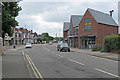
10
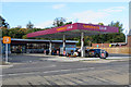
West Bridgford: Sainsbury's Local, Melton Road
A recently-built filling station and convenience store. Image] gives an idea of the site in May 2017.
Image: © John Sutton
Taken: 26 Sep 2018
0.08 miles