IMAGES TAKEN NEAR TO
Edwalton Avenue, NOTTINGHAM, NG2 6BD
Introduction
This page details the photographs taken nearby to Edwalton Avenue, NG2 6BD by members of the Geograph project.
The Geograph project started in 2005 with the aim of publishing, organising and preserving representative images for every square kilometre of Great Britain, Ireland and the Isle of Man.

There are currently over 7.5m images from over14,400 individuals and you can help contribute to the project by visiting https://www.geograph.org.uk
Image Map
Images are licensed for reuse under creativecommons.org/licenses/by-sa/2.0
Notes
- Clicking on the map will re-center to the selected point.
- The higher the marker number, the further away the image location is from the centre of the postcode.
Image Listing (163 Images Found)
Images are licensed for reuse under creativecommons.org/licenses/by-sa/2.0
Image
Details
Distance
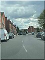
1
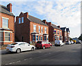
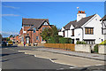
West Bridgford: constituency offices, Rectory Road
Behind the red car are typical Bridgford villas which house the constituency offices of the local MP, Rt Hon Kenneth Clarke, who at the time this photograph was taken was Father of the House.
Image: © John Sutton
Taken: 7 Sep 2018
0.03 miles
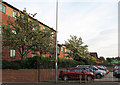
2
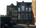
West Bridgford Infants School
Unusually still housed in this imposing Victorian building.
Image: © Alan Murray-Rust
Taken: 7 Mar 2010
0.04 miles
3
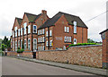
West Bridgford Infant School
Dating from 1895, this was Musters Road Elementary School when my mother and her brother and sisters were here in the 1920s.
Image: © John Sutton
Taken: 28 May 2017
0.05 miles
4
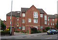
Giles Court, Rectory Road
West Bridgford's population rose from 293 in 1881 to 7,018 twenty years later. It is essentially a Victorian and Edwardian suburb, which is why the narrow strip of new houses running parallel to Stratford Road between Bridgford Road and Melton Road shows up so clearly on aerial photos. These flats stand where there was once a railway embankment, now levelled, which carried the Nottingham-Melton-Oakham-Corby-Kettering line on which the fastest trains from Nottingham Midland to London St Pancras ran. There was of course a skew bridge over Rectory Road; fifty years ago I would have stood underneath it to look in this direction.
Image: © John Sutton
Taken: 4 May 2011
0.05 miles
5
West Bridgford: on Rectory Road
The white house on the corner of Stratford Road is, I think, a little older than most of Bridgford's red-brick villas.
Image: © John Sutton
Taken: 7 Sep 2018
0.05 miles
6
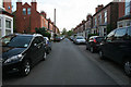
Stratford Road, West Bridgford
During the fast growth of Nottingham in the Victorian period pressure was put on the Musters Family, who owned much of the land in West Bridgford, to allow suburban development south of the River Trent. Eventually the Musters sold their land, but they put in place strict planning regulations to the area then known as the West Bridgford Estate. This development was planned over a grid of tree lined streets. The main roads such as Musters Road (see Image) had restrictions on the density of housing and house size. Smaller houses were permitted on side streets, and terraces were erected on roads such as Stratford Road for the servants of the wealthy Nottingham merchants who bought up the larger properties.
It is interesting to note that there are no "Streets" in West Bridgford. Originally many roads were name "Street" but this was felt to be too urban by the Victorian "planners". Thus all street names were changed from "Street" to "Road". The one exception is "Village Street" in Edwalton, a village that has been totally absorbed into the town of West Bridgford.
Image: © Kate Jewell
Taken: 22 Apr 2009
0.05 miles
7
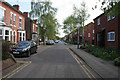
Stratford Road, West Bridgford
With the modern retirement housing of Church Croft on the right.
Image: © Kate Jewell
Taken: 22 Apr 2009
0.08 miles
8
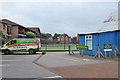
West Bridgford: Musters Sports and Social Club
The Musters Tennis Club and the West Bridgford Bowling Club are based here. The Marlborough Court flats on the left were built on the levelled site of the Midland Railway embankment which until 1968 carried the quickest trains between Nottingham Midland and London St Pancras, via Melton Mowbray and Oakham.
Image: © John Sutton
Taken: 11 Sep 2019
0.08 miles
10
Rectory Road: where the railway once ran
West Bridgford's population rose from 293 in 1881 to 7,018 twenty years later. It is essentially a Victorian and Edwardian suburb, which is why the narrow strip of new houses running parallel to Stratford Road between Bridgford Road and Melton Road shows up so clearly on aerial photos. These flats stand where there was once a railway embankment, now levelled, which carried the Nottingham-Melton-Oakham-Corby-Kettering line on which the fastest trains from Nottingham Midland to London St Pancras ran.
Image: © John Sutton
Taken: 4 May 2011
0.09 miles