IMAGES TAKEN NEAR TO
Cambridge Road, NOTTINGHAM, NG2 5NA
Introduction
This page details the photographs taken nearby to Cambridge Road, NG2 5NA by members of the Geograph project.
The Geograph project started in 2005 with the aim of publishing, organising and preserving representative images for every square kilometre of Great Britain, Ireland and the Isle of Man.

There are currently over 7.5m images from over14,400 individuals and you can help contribute to the project by visiting https://www.geograph.org.uk
Image Map
Images are licensed for reuse under creativecommons.org/licenses/by-sa/2.0
Notes
- Clicking on the map will re-center to the selected point.
- The higher the marker number, the further away the image location is from the centre of the postcode.
Image Listing (38 Images Found)
Images are licensed for reuse under creativecommons.org/licenses/by-sa/2.0
Image
Details
Distance
1
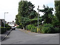
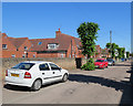
Abbey Circus, West Bridgford
The trees and shrubs on the right of the photo mark part of the boundary of a triangular open space.
Image: © Oxymoron
Taken: 23 Jul 2008
0.10 miles
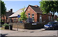
2
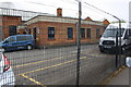
Building at Nottinghamshire County Council Depot
Former bus depot building with OS benchmark Image on its near corner, right hand face.
Image: © Roger Templeman
Taken: 12 May 2018
0.10 miles
3
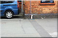
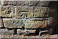
Benchmark on Abbey Road Depot
The Ordnance Survey cut mark benchmark, in the black bricks at the left hand corner of the building, is described on the Bench Mark Database at https://www.bench-marks.org.uk/bm102398
Image: © Roger Templeman
Taken: 12 May 2018
0.10 miles
4
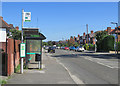
West Bridgford: along Gordon Road
Because of road works and temporary re-routing of the No 6 service from Edwalton this bus stop was out of use.
Image: © John Sutton
Taken: 3 Jul 2019
0.12 miles
5
Benchmark on Exchange Road wall outside West Bridgford Junior School
Ordnance Survey cut mark benchmark levelled at 25.887m above Newlyn Datum with additional information to be found on the Bench Mark Database at www.bench-marks.org.uk/bm112892
Image: © Roger Templeman
Taken: 14 May 2018
0.14 miles
6
West Bridgford Junior School, at Exchange Road / Carnarvon Road junction
There is an OS benchmark Image on the Exchange Road (left hand) side of the wall corner, level with the no through road sign
Image: © Roger Templeman
Taken: 14 May 2018
0.14 miles
7
West Bridgford Junior School, Exchange Road
The school was formerly known as South County Junior.
Image: © John Sutton
Taken: 3 Jul 2019
0.14 miles
9
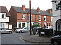
The corner of Manvers Road and Exchange Road
Image: © John Sutton
Taken: 30 Jun 2009
0.14 miles
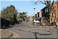
10
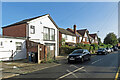
West Bridgford: Ethel Road on a September morning
Ethel Road links Exchange Road and Gordon Road (ahead). The picture was taken on a mild, cloudless and summery morning at the end of September.
Image: © John Sutton
Taken: 29 Sep 2023
0.14 miles