IMAGES TAKEN NEAR TO
Brockley Road, NOTTINGHAM, NG2 5JY
Introduction
This page details the photographs taken nearby to Brockley Road, NG2 5JY by members of the Geograph project.
The Geograph project started in 2005 with the aim of publishing, organising and preserving representative images for every square kilometre of Great Britain, Ireland and the Isle of Man.

There are currently over 7.5m images from over14,400 individuals and you can help contribute to the project by visiting https://www.geograph.org.uk
Image Map
Images are licensed for reuse under creativecommons.org/licenses/by-sa/2.0
Notes
- Clicking on the map will re-center to the selected point.
- The higher the marker number, the further away the image location is from the centre of the postcode.
Image Listing (76 Images Found)
Images are licensed for reuse under creativecommons.org/licenses/by-sa/2.0
Image
Details
Distance
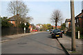
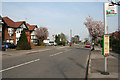
1
Brockley Road bus stop
This was the terminus of bus services from Nottingham from before the war until around 1980 when Buckfast Way was opened.
Image: © Alan Murray-Rust
Taken: 13 Dec 2009
0.01 miles
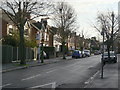
2
Brockley Road, West Bridgford
Looking towards Davies Road.
Image: © Kate Jewell
Taken: 10 Apr 2010
0.02 miles
3
Eltham Road, West Bridgford
Looking towards the Grantham Canal and the allotment gardens. This is the eastern edge of West Bridgford. The highly and recently developed village of Gamston is the other side of the canal.
Image: © Kate Jewell
Taken: 10 Apr 2010
0.05 miles
4
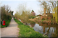
Canal towpath, Grantham Canal
Looking towards the bridges at Radcliffe Road.
Opened in 1994 the building on the right is the Nottingham Pet Crematorium.
Image: © Kate Jewell
Taken: 10 Apr 2010
0.07 miles
5
Gamston Canal from Gamston Bridge
The widening of the canal here is a winding hole to allow boats to turn round.
Image: © Alan Murray-Rust
Taken: 13 Dec 2009
0.07 miles
7
The Grantham Canal at Gamston Bridge
The canal opened in 1797 and was abandoned in 1936.
Image: © John Sutton
Taken: 29 Jun 2015
0.07 miles
8
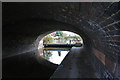
Under Gamston Bridge (2)
Looking south through the older Bridge 4A. This bridge, carrying the Nottingham bound carriageway of Radford Road over the canal, is high enough to allow craft to pass underneath. That is if there wasn't a large sewerage pipe crossing just above water level. A major obstacle to the reopening of the canal is Bridge 4 which is behind the viewpoint. This was constructed during the dual-ling of Radcliffe Road with scant regard for future use of the waterway. This is the main reason why a feasibility study to look into alternative routes to the River Trent was carried out in 2009.
Image: © Kate Jewell
Taken: 10 Apr 2010
0.07 miles
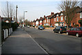
9
Davies Road, West Bridgford
Looking towards the junction with the A6011, Radcliffe Road.
Image: © Kate Jewell
Taken: 10 Apr 2010
0.07 miles
10
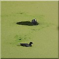
A coot and child
Amidst thick azolla on the Grantham Canal.
Image: © David Lally
Taken: 13 Jul 2018
0.07 miles