IMAGES TAKEN NEAR TO
Florence Road, NOTTINGHAM, NG2 5HR
Introduction
This page details the photographs taken nearby to Florence Road, NG2 5HR by members of the Geograph project.
The Geograph project started in 2005 with the aim of publishing, organising and preserving representative images for every square kilometre of Great Britain, Ireland and the Isle of Man.

There are currently over 7.5m images from over14,400 individuals and you can help contribute to the project by visiting https://www.geograph.org.uk
Image Map
Images are licensed for reuse under creativecommons.org/licenses/by-sa/2.0
Notes
- Clicking on the map will re-center to the selected point.
- The higher the marker number, the further away the image location is from the centre of the postcode.
Image Listing (135 Images Found)
Images are licensed for reuse under creativecommons.org/licenses/by-sa/2.0
Image
Details
Distance
1
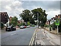
West Bridgford: bin day on Florence Road
Dustbin men at work on a September morning.
Image: © John Sutton
Taken: 8 Sep 2016
0.01 miles
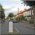
2
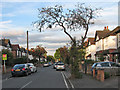
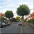
Florence Road, West Bridgford
Residential street of mixed style Edwardian housing to the east of Bridgford Park.
Image: © Kate Jewell
Taken: 11 Mar 2010
0.03 miles
3
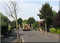
West Bridgford: Violet Road
At about eight o'clock on a sunny August evening.
Image: © John Sutton
Taken: 13 Aug 2016
0.07 miles
4
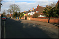
West Bridgford: Florence Road
Seen from the corner of Albert Road on a sunny August evening.
Image: © John Sutton
Taken: 13 Aug 2016
0.07 miles
5
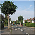
West Bridgford: on Florence Road
The junction with Abbey Road.
Image: © John Sutton
Taken: 8 Sep 2016
0.08 miles
6
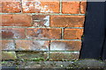
Benchmark on wall in front of #44A Albert Road
Ordnance Survey cut mark benchmark described on the Bench Mark Database at https://www.bench-marks.org.uk/bm102396
Image: © Roger Templeman
Taken: 12 May 2018
0.09 miles
7
Nos. 44 and 44A Albert Road at Violet Road junction
There is an OS benchmark Image at the right hand end of the brick wall in front of #44A at the junction with the wooden fence in front of #44
Image: © Roger Templeman
Taken: 12 May 2018
0.10 miles
8
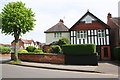
West Bridgford: Priory Road
A view from the corner of Albert Road, taken on a sunny August evening.
Image: © John Sutton
Taken: 13 Aug 2016
0.11 miles
9

Canal Lifting Bridge
This is an old lifting bridge over the Grantham Canal at the junction of Radcliffe Road and Rutland Road. The Bridge was built in 1929 and demolished 19th November 1953. I rescued the photograph from being thrown out of our office at Rushcliffe Borough Council. The photograph was taken by Mr E Hackworth 1/50s at F11 H.P.3. The car travelling over the bridge is a Morris Minor MM 918 cc side valve and a forerunner to the Morris 1000
Image: © Gareth R Jones
Taken: 16 Nov 1953
0.11 miles