IMAGES TAKEN NEAR TO
Radcliffe Road, NOTTINGHAM, NG2 5FX
Introduction
This page details the photographs taken nearby to Radcliffe Road, NG2 5FX by members of the Geograph project.
The Geograph project started in 2005 with the aim of publishing, organising and preserving representative images for every square kilometre of Great Britain, Ireland and the Isle of Man.

There are currently over 7.5m images from over14,400 individuals and you can help contribute to the project by visiting https://www.geograph.org.uk
Image Map (Loading...)


Getting Data...Please wait
Leaflet Map data © OpenStreetMap
Images are licensed for reuse under creativecommons.org/licenses/by-sa/2.0
Notes
- Clicking on the map will re-center to the selected point.
- The higher the marker number, the further away the image location is from the centre of the postcode.
Image Listing (484 Images Found)
Images are licensed for reuse under creativecommons.org/licenses/by-sa/2.0
Image
Details
Distance
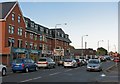
1
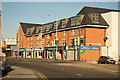
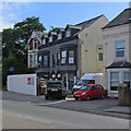
Radcliffe Road
Shops and flats on Radcliffe Road, West Bridgford
Image: © Richard Croft
Taken: 9 Sep 2012
0.00 miles
2
An April morning in Radcliffe Road
It was bright and cold at seven o'clock on Good Friday morning. This is the view towards Lady Bay, near where the Nottingham-Melton-Kettering-London railway once crossed. For more about that, see Image], taken the previous September.
Image: © John Sutton
Taken: 6 Apr 2012
0.01 miles
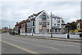
3
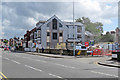
Radcliffe Road: conversion to flats
The former Gallery Hotel is being converted to flats. Image] shows the state of play in January 2017.
Image: © John Sutton
Taken: 31 Aug 2017
0.02 miles
4
Radcliffe Road: converting the Gallery Hotel
The former hotel is being converted to flats.
Image: © John Sutton
Taken: 23 Jan 2017
0.02 miles
5
Radcliffe Road: The Gallery
The grey building is The Gallery, formerly an hotel, now flats.
Image] (January 2017)
Image] (August 2017)
Image: © John Sutton
Taken: 26 Apr 2019
0.02 miles
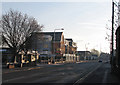
6
Radcliffe Road: where the railway once crossed
From 1879 until it closed in 1968 the railway from Nottingham Midland to Melton Mowbray (used by St Pancras expresses) crossed Radcliffe Road here, on a plate girder bridge. The Bathstore stands where the embankment was. Cars leaving Bridgford will either carry on along Radcliffe Road towards the Vale of Belvoir and Grantham or turn left towards the city and cross Lady Bay Bridge, the former railway bridge over the Trent.
Image: © John Sutton
Taken: 13 Sep 2011
0.02 miles
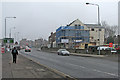
7
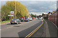
Lady Bay Bridge, West Bridgford
Traffic heading out of Nottingham towards West Bridgford and the country villages beyond.
This used to be the route of the Nottingham to Melton railway.
Image: © Kate Jewell
Taken: 1 May 2008
0.03 miles
8
Former course of the Midland main line
This snap may only be of interest to bathroom or railway enthusiasts. The new building ahead stands where the Midland Railway main line from Nottingham to St Pancras via Melton Mowbray, Oakham, Corby and Kettering, closed in the 1960s, once crossed Radcliffe Road on a plate girder bridge. I stood where there was once an embankment to take the picture. The Melton line, which carried Nottingham's quickest London trains and brought iron ore north from Northamptonshire, turned south at London Road Junction, crossed the Trent on what is now the Lady Bay road bridge and ran north and south through West Bridgford, where its course shows clearly on the 1:25,000 map, and on the ground as a strip of new buildings built where there were once embankments.
Image] and Image] show remains of the line south of here.
Image: © John Sutton
Taken: 15 Apr 2011
0.03 miles
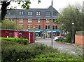
9
West Bridgford: converting the Grantham Hotel
The hotel closed in 2018 and is being converted to flats. The 1970s stone cladding has been removed from the frontage since I took Image] and Image] earlier in 2019.
Image: © John Sutton
Taken: 18 Sep 2019
0.03 miles
10
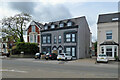
The former Grantham Hotel
The former Grantham Hotel was built as semi-detached villas and has recently been converted to flats.
Earlier pictures:
Image] (April 2019)
Image] (July 2019)
Image] (September 2019)
Image: © John Sutton
Taken: 23 May 2021
0.03 miles