IMAGES TAKEN NEAR TO
Pavilion Road, NOTTINGHAM, NG2 5FG
Introduction
This page details the photographs taken nearby to Pavilion Road, NG2 5FG by members of the Geograph project.
The Geograph project started in 2005 with the aim of publishing, organising and preserving representative images for every square kilometre of Great Britain, Ireland and the Isle of Man.

There are currently over 7.5m images from over14,400 individuals and you can help contribute to the project by visiting https://www.geograph.org.uk
Image Map
Images are licensed for reuse under creativecommons.org/licenses/by-sa/2.0
Notes
- Clicking on the map will re-center to the selected point.
- The higher the marker number, the further away the image location is from the centre of the postcode.
Image Listing (815 Images Found)
Images are licensed for reuse under creativecommons.org/licenses/by-sa/2.0
Image
Details
Distance
1
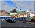
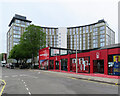
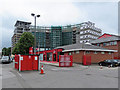
West Bridgford: adapting the former council offices
The large curved building was built in the 1960s as an hotel but was for many years used as offices by Rushcliffe Borough Council. It is now being converted to flats and extended at each end. This photograph was taken from Radcliffe Road. Image] is a comparable view, taken from Trent Bridge Cricket Ground in 2018.
Image: © John Sutton
Taken: 5 Apr 2019
0.01 miles
2
Up Pavilion Road
Looking towards where the A60 slopes down from Trent Bridge. The sun was reluctant to break through and took till later in the afternoon.
Image: © John Sutton
Taken: 1 Jun 2018
0.02 miles
3
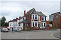
Nottingham Forest Sportsmen's Club
At the bend in Pavilion Road, near the main entrance to Nottingham Forest's City Ground.
Image: © John Sutton
Taken: 13 Jul 2019
0.02 miles
4
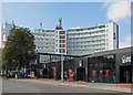
Nottingham Forest shop and ticket office
A view from the main gate of the City Ground on Pavilion Road. The Rushcliffe Borough Council offices in the background were built in the 1960s as an hotel, on the site of the Pavilion Cinema.
Image: © John Sutton
Taken: 11 Sep 2014
0.02 miles
5
First an hotel, then offices, now flats
The Waterside Apartments were converted from the former Rushcliffe Borough Council offices, which were built as an hotel in the 1960s. The red building is Nottingham Forest FC's shop - the football ground is behind the camera. Image] shows building work in September 2019 and has links to earlier views.
Image: © John Sutton
Taken: 20 May 2021
0.02 miles
6
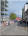
Match day on Pavilion Road
Nottingham Forest fans arriving early for a second-division match. This was a dreadful day for Nottingham sport: at Trent Bridge Nottinghamshire had lost dreadfully to Somerset by an innings and 14 runs by ten to three on the third day, and by ten to five Forest had lost 1-2 to Blackburn Rovers and Notts County, bottom of the fourth division and looking doomed to drop out of the Football League, had lost 3-0 at Crewe. But we'll all be back next match, no doubt....
Image: © John Sutton
Taken: 13 Apr 2019
0.02 miles
7
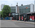
Nottingham Forest shop and former council offices
A view from the main gate of the City Ground on Pavilion Road. The Rushcliffe Borough Council offices in the background, now being converted to flats, were built in the 1960s as an hotel, on the site of the Pavilion Cinema. Image] is a comparable view taken some years earlier.
Image: © John Sutton
Taken: 1 Jun 2018
0.03 miles
8
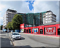
Waterside Apartments and the Nottingham Forest shop
The former Rushcliffe Borough Council offices are being converted to flats.
Comparable earlier views:
Image] (September 2014)
Image] (June 2018)
Image] (July 2019)
Image: © John Sutton
Taken: 11 Sep 2019
0.03 miles
9
Waterside Apartments from the City Ground
The former Rushcliffe Borough Council offices are being converted to flats.
Comparable earlier views:
Image] (September 2014)
Image] (June 2018)
Image: © John Sutton
Taken: 13 Jul 2019
0.03 miles
10
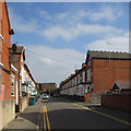
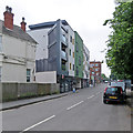
West Bridgford: Rosebery Avenue
A street of terraced houses between Nottingham Forest football ground (to the left) and Radcliffe Road.
Image: © John Sutton
Taken: 11 Sep 2014
0.04 miles