IMAGES TAKEN NEAR TO
Rutland Road, NOTTINGHAM, NG2 5DR
Introduction
This page details the photographs taken nearby to Rutland Road, NG2 5DR by members of the Geograph project.
The Geograph project started in 2005 with the aim of publishing, organising and preserving representative images for every square kilometre of Great Britain, Ireland and the Isle of Man.

There are currently over 7.5m images from over14,400 individuals and you can help contribute to the project by visiting https://www.geograph.org.uk
Image Map
Images are licensed for reuse under creativecommons.org/licenses/by-sa/2.0
Notes
- Clicking on the map will re-center to the selected point.
- The higher the marker number, the further away the image location is from the centre of the postcode.
Image Listing (113 Images Found)
Images are licensed for reuse under creativecommons.org/licenses/by-sa/2.0
Image
Details
Distance
1
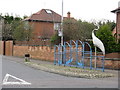
Bird Stop
A most unusual adjunct to a bus stop, found on Rutland Road, Nottingham.
Image: © Peter Whatley
Taken: 22 Mar 2009
0.02 miles
2
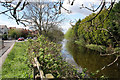
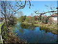
The Grantham Canal
Looking towards the River Trent from Mabel Grove Bridge. See http://www.granthamcanal.com/ for more information about the canal and its restoration.
Image: © Kate Jewell
Taken: 1 May 2008
0.05 miles
3
Grantham Canal in West Bridgford, Nottingham
Image: © Mat Fascione
Taken: 12 Nov 2017
0.05 miles
4
Houses next to the Grantham Canal
The houses are on Ropsley Crescent in West Bridgford, Nottingham.
Image: © Mat Fascione
Taken: 12 Nov 2017
0.05 miles
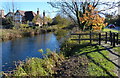
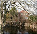
5

The Grantham Canal from Rutland Road
Rutland Road is now a flat crossing, but there was once a lifting bridge across the long-abandoned canal - see Image], which brings back memories of my early childhood. The photograph was taken against the light on a spring evening.
Image: © John Sutton
Taken: 4 May 2011
0.06 miles
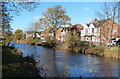
6
Grantham Canal, Lady Bay
Although long disused as a waterway, there is still water in the canal as it passes through suburban West Bridgford.
Image: © Stephen McKay
Taken: 18 Apr 2015
0.06 miles
8
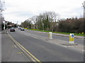
Rutland Road, Lady Bay
Lady Bay, although part of West Bridgford, is a distinct area between the A52 and the River Trent. Before it was built upon by the Victorians in the 19th century it was basically two very large fields and a wet marshy place by the river. Today it has its own personality, almost like a village. The main routes into the area are marked by these crane "gates" and there is a 20 mph speed limit throughout.
Image: © Kate Jewell
Taken: 1 May 2008
0.07 miles
9
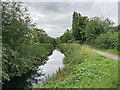
West Bridgford: a stretch of the Grantham Canal
The canal was abandoned in 1936. This truncated stretch is the nearest to the River Trent.
Image: © John Sutton
Taken: 28 Jul 2023
0.07 miles
10
Rutland Road blocks the Grantham Canal
The scene of Image
The short road which connects Radcliffe Road to Rutland Road, does not appear to have a name of its own so I expect is classed as part of the latter.
Image: © David Lally
Taken: 21 Jan 2010
0.08 miles