IMAGES TAKEN NEAR TO
Fleeman Grove, NOTTINGHAM, NG2 5BH
Introduction
This page details the photographs taken nearby to Fleeman Grove, NG2 5BH by members of the Geograph project.
The Geograph project started in 2005 with the aim of publishing, organising and preserving representative images for every square kilometre of Great Britain, Ireland and the Isle of Man.

There are currently over 7.5m images from over14,400 individuals and you can help contribute to the project by visiting https://www.geograph.org.uk
Image Map
Images are licensed for reuse under creativecommons.org/licenses/by-sa/2.0
Notes
- Clicking on the map will re-center to the selected point.
- The higher the marker number, the further away the image location is from the centre of the postcode.
Image Listing (101 Images Found)
Images are licensed for reuse under creativecommons.org/licenses/by-sa/2.0
Image
Details
Distance
1
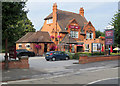
Trent Boulevard: the Lady Bay
This building has been a Greene King pub for a long time now, but it wasn't one in the immediate post-war years. I wish I could remember what it was then.
Image: © John Sutton
Taken: 5 Sep 2018
0.05 miles
2
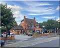
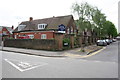
West Bridgford: The Lady Bay and a stinkpipe
To the left of the pub car park entrance, partly covered by foliage, is a rusty cast-iron sewer vent pipe of a kind found elsewhere in Bridgford (see Image]).
Image: © John Sutton
Taken: 2 Aug 2022
0.05 miles
3

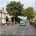
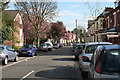
Trent Boulevard on a September evening
A view from the corner of Belvoir Road, with Lady Bay Primary School on the right and the Lady Bay pub opposite. Diseased horse chestnuts are the first trees to brown each autumn.
Image: © John Sutton
Taken: 9 Sep 2014
0.05 miles
4
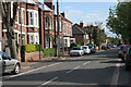
Trent Boulevard and a No 11 bus
A city-bound bus passing Lady Bay Primary School early on a sunny September evening.
Image: © John Sutton
Taken: 5 Sep 2018
0.05 miles
7
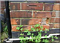
Benchmark on #62 Holme Road
Ordnance Survey cut mark benchmark described on the Bench Mark Database at https://www.bench-marks.org.uk/bm102389
Image: © Roger Templeman
Taken: 12 May 2018
0.06 miles
8
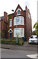
#62 Holme Road
There is an OS benchmark Image on the right hand side of the house near its front corner
Image: © Roger Templeman
Taken: 12 May 2018
0.06 miles
9
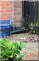
Benchmark on Lady Bay Primary School, Belvoir Road face
The Ordnance Survey cut mark benchmark, most of which is behind a downpipe, is described on the Bench Mark Database at https://www.bench-marks.org.uk/bm102390
Image: © Roger Templeman
Taken: 12 May 2018
0.06 miles
10
Lady Bay Primary School at Belvoir Road / Trent Boulevard junction
There is an OS benchmark Image on the near corner, right hand face, of the school
Image: © Roger Templeman
Taken: 12 May 2018
0.06 miles