IMAGES TAKEN NEAR TO
Gorsy Lane, SOUTHWELL, NG25 0XH
Introduction
This page details the photographs taken nearby to Gorsy Lane, NG25 0XH by members of the Geograph project.
The Geograph project started in 2005 with the aim of publishing, organising and preserving representative images for every square kilometre of Great Britain, Ireland and the Isle of Man.

There are currently over 7.5m images from over14,400 individuals and you can help contribute to the project by visiting https://www.geograph.org.uk
Image Map
Images are licensed for reuse under creativecommons.org/licenses/by-sa/2.0
Notes
- Clicking on the map will re-center to the selected point.
- The higher the marker number, the further away the image location is from the centre of the postcode.
Image Listing (12 Images Found)
Images are licensed for reuse under creativecommons.org/licenses/by-sa/2.0
Image
Details
Distance
1
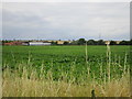
Lodge Farm
The low hills beyond form the western edge of the Trent Valley.
Image: © Jonathan Thacker
Taken: 21 Jul 2017
0.03 miles

3

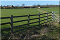
Stile south of Gorsy Lane, near Morton
An apparently reasonably avoidable stile crossed by a public footpath that parallels Marlock Dyke (on the other side of the hedge on the right).
Image: © Richard Vince
Taken: 17 Apr 2014
0.05 miles
4

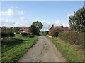
Track to Fiskerton Grange
Seen from Gorsy Lane. The sign on the right indicates that the track is also a public footpath.
Image: © Richard Vince
Taken: 17 Apr 2014
0.10 miles
8
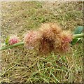
Rose gall, aka Robin's Pincushion, Gorsy Lane, Morton
A cluster of galls, formed by the gall wasp Diplolepis rosae. https://en.wikipedia.org/wiki/Diplolepis_rosae
Image: © Alan Murray-Rust
Taken: 17 Aug 2020
0.19 miles
9
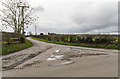
Junction on Main Street
The junction of Main Street, Gorsy Lane (ahead) and Cooks Lane.
I'm not sure what the block paved triangle is for.
Image: © Julian P Guffogg
Taken: 27 Jan 2016
0.19 miles
10

Road junction south of Morton
The junction of Gorsy Lane (foreground) with Main Street (left, leading to the village) and Cook's Lane.
Image: © Richard Vince
Taken: 17 Apr 2014
0.21 miles