IMAGES TAKEN NEAR TO
The Paddocks, SOUTHWELL, NG25 0WA
Introduction
This page details the photographs taken nearby to The Paddocks, NG25 0WA by members of the Geograph project.
The Geograph project started in 2005 with the aim of publishing, organising and preserving representative images for every square kilometre of Great Britain, Ireland and the Isle of Man.

There are currently over 7.5m images from over14,400 individuals and you can help contribute to the project by visiting https://www.geograph.org.uk
Image Map
Images are licensed for reuse under creativecommons.org/licenses/by-sa/2.0
Notes
- Clicking on the map will re-center to the selected point.
- The higher the marker number, the further away the image location is from the centre of the postcode.
Image Listing (33 Images Found)
Images are licensed for reuse under creativecommons.org/licenses/by-sa/2.0
Image
Details
Distance
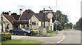
1
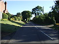
Caunton Road
Heading north out of Hockerton.
Image: © JThomas
Taken: 7 Sep 2013
0.05 miles
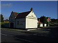
3
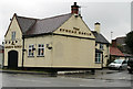
The Spread Eagle Pub, Hockerton
On A617.
Image: © J.Hannan-Briggs
Taken: 10 Feb 2013
0.07 miles
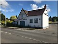
4
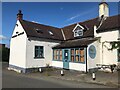
The (ex) Spread Eagle, Hockerton
Not been a pub for a while I think.
Image: © David Lally
Taken: 19 Jun 2022
0.07 miles
6
The (ex) Spread Eagle, Hockerton
Closed for some time I think.
Image: © David Lally
Taken: 19 Jun 2022
0.07 miles
8
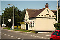
The Spread Eagle
Hostelry in Hockerton
Image: © Richard Croft
Taken: 24 Jul 2012
0.07 miles
9
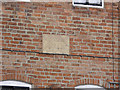
Datestone on Bank Cottage
See http://www.geograph.org.uk/photo/3429772 for the location view.
Image: © Alan Murray-Rust
Taken: 21 Apr 2013
0.07 miles
10
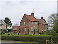
Bank Cottage and neighbour
Not built as a pair, the further one dating from the late 18th century, the nearer (Bank Cottage) having a datestone inscribed 1811, an unusual feature for a small building like this. Listed Grade II.
Image: © Alan Murray-Rust
Taken: 21 Apr 2013
0.07 miles