IMAGES TAKEN NEAR TO
Manor Drive, SOUTHWELL, NG25 0UZ
Introduction
This page details the photographs taken nearby to Manor Drive, NG25 0UZ by members of the Geograph project.
The Geograph project started in 2005 with the aim of publishing, organising and preserving representative images for every square kilometre of Great Britain, Ireland and the Isle of Man.

There are currently over 7.5m images from over14,400 individuals and you can help contribute to the project by visiting https://www.geograph.org.uk
Image Map
Images are licensed for reuse under creativecommons.org/licenses/by-sa/2.0
Notes
- Clicking on the map will re-center to the selected point.
- The higher the marker number, the further away the image location is from the centre of the postcode.
Image Listing (81 Images Found)
Images are licensed for reuse under creativecommons.org/licenses/by-sa/2.0
Image
Details
Distance
1
Middle Lane, Morton
There is a benchmark http://www.geograph.org.uk/photo/6573809 on the wall in front of the tree.
Image: © Alan Murray-Rust
Taken: 17 Aug 2020
0.04 miles
2

Bench mark, Middle Lane, Morton
See http://www.geograph.org.uk/photo/6573807 for location.
Image: © Alan Murray-Rust
Taken: 17 Aug 2020
0.04 miles
3

Cottages on Church Lane, Morton
Recently reroofed, it would appear. The church alluded to in the name of the road nestles in the trees visible to the right of the cottages.
Image: © Richard Vince
Taken: 17 Apr 2014
0.05 miles
4
1 & 2 Church Lane, Morton
Probably early 19th century; there is a fire mark http://www.geograph.org.uk/photo/6568217 on the gable.
Image: © Alan Murray-Rust
Taken: 9 Aug 2020
0.05 miles
5
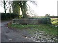
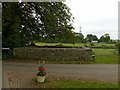
Morton pinfold
Restored in 1987. At the junction of Moor Lane and Causeway Lane
Image: © Tim Heaton
Taken: 23 Nov 2008
0.05 miles
6
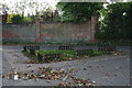
Grass triangle opposite Morton Pinfold
It has grown some pieces of fence since the 2012 photo, perhaps as a deterrent to driving your car across it. See Image
Image: © Chris
Taken: 19 Oct 2014
0.06 miles
7
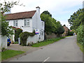
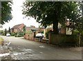
Middle Lane, Morton
The road towards Southwell. The name doubtless derives from the fact that it lies between Back Lane and Church Lane.
Image: © Alan Murray-Rust
Taken: 14 Sep 2012
0.06 miles
8
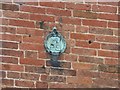
Fire mark, 1 Church Lane, Morton
An old Notts and Derbys Fire Insurance plaque, very battered, and fixed upside-down. See http://www.geograph.org.uk/photo/6568215 for location.
Image: © Alan Murray-Rust
Taken: 9 Aug 2020
0.06 miles
9
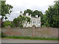
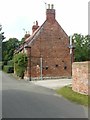
Morton Hall
Large house at the western end of the village, dating back to possibly 1740, with extension from around 100 years later.
Image: © Alan Murray-Rust
Taken: 14 Sep 2012
0.06 miles
10
Morton Pinfold
Less covered in ivy than when I visited in 2012 https://www.geograph.org.uk/photo/3136978
Image: © Alan Murray-Rust
Taken: 9 Aug 2020
0.06 miles