IMAGES TAKEN NEAR TO
Fiskerton Road, SOUTHWELL, NG25 0TH
Introduction
This page details the photographs taken nearby to Fiskerton Road, NG25 0TH by members of the Geograph project.
The Geograph project started in 2005 with the aim of publishing, organising and preserving representative images for every square kilometre of Great Britain, Ireland and the Isle of Man.

There are currently over 7.5m images from over14,400 individuals and you can help contribute to the project by visiting https://www.geograph.org.uk
Image Map
Images are licensed for reuse under creativecommons.org/licenses/by-sa/2.0
Notes
- Clicking on the map will re-center to the selected point.
- The higher the marker number, the further away the image location is from the centre of the postcode.
Image Listing (79 Images Found)
Images are licensed for reuse under creativecommons.org/licenses/by-sa/2.0
Image
Details
Distance
1
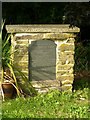
Commemorative monument, the 'South Well'
The text explains that this is close to the site of the spring which gave the town its name.
Image: © Alan Murray-Rust
Taken: 13 Sep 2020
0.02 miles
2
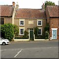
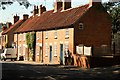
Clinton House, 61 Fiskerton Road Southwell
An attractive small Georgian house, nestled between two terraces of smaller cottages. Built c.1800, Listed Grade II. A feature of the house is the elaborate window lintels.
The garden wall and gate are separately Listed Grade II.
Image: © Alan Murray-Rust
Taken: 13 Sep 2020
0.02 miles
3
Houses opposite Crink Lane Junction, Easthorpe
Image: © Chris
Taken: 23 Jun 2018
0.02 miles
4
Junction of Crink Lane and Spring Hill, Easthorpe
Image: © Chris
Taken: 23 Jun 2018
0.02 miles
5

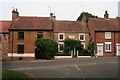
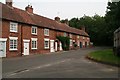
63 ? 75 Fiskerton Road, Southwell
An attractive row of probably early 19th century terraced cottages.
Image: © Alan Murray-Rust
Taken: 13 Sep 2020
0.03 miles
6
Cottages on Spring Hill
Pretty 19th century cottages on Spring Hill at Easthorpe
Image: © Richard Croft
Taken: 24 Jul 2012
0.04 miles
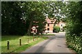
8
Pollard's Lane, off Fiskerton Road, Southwell
Image: © Chris
Taken: 23 Jun 2018
0.11 miles
9

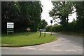
Boundary wall at Easthorpe House
Early 19th century, Listed Grade II. See also http://www.geograph.org.uk/photo/6590625 . Looking south along Fiskerton Road.
Image: © Alan Murray-Rust
Taken: 30 Aug 2020
0.12 miles
10
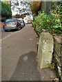
Old Milestone on Church Street, 10m North of Cottams Cottage
The Milestone is located on the footpath next to a low wall on the East of the road. Parish of Southwell (Newark & Sherwood District). Carved stone post, erected in the 19th Century.
Inscription reads:-
TO / FISKERTON / 2½ Mile
Milestone Society National ID: NT_FISO02
Image: © Hilary Jones
Taken: 8 Oct 2023
0.12 miles