IMAGES TAKEN NEAR TO
Hatfield Lane, SOUTHWELL, NG25 0TA
Introduction
This page details the photographs taken nearby to Hatfield Lane, NG25 0TA by members of the Geograph project.
The Geograph project started in 2005 with the aim of publishing, organising and preserving representative images for every square kilometre of Great Britain, Ireland and the Isle of Man.

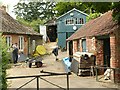
There are currently over 7.5m images from over14,400 individuals and you can help contribute to the project by visiting https://www.geograph.org.uk
Image Map
Images are licensed for reuse under creativecommons.org/licenses/by-sa/2.0
Notes
- Clicking on the map will re-center to the selected point.
- The higher the marker number, the further away the image location is from the centre of the postcode.
Image Listing (58 Images Found)
Images are licensed for reuse under creativecommons.org/licenses/by-sa/2.0
Image
Details
Distance
2
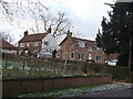
The Cottage and Lilac Cottage
The former is a fairly typical double front cottage of the 19th century. The nearer Lilac Cottage is clearly much altered. There is evidence from the gable end that the roof has been raised by a few feet, doubtless to create the upper storey.
Image: © Alan Murray-Rust
Taken: 18 Dec 2009
0.04 miles
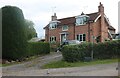
4
Wesley House, Forest Road, Oxton
Early 18th century former farmhouse with additions from the 19th and 20th centuries. Listed Grade II.
Image: © Alan Murray-Rust
Taken: 16 Jul 2020
0.08 miles
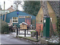
5
The Old Forge, Oxton
Classic village workshops, the business being continuous from around the middle of the 19th century (c.1840). The forge building on the right is Listed Grade II. My comment on my 2009 view https://www.geograph.org.uk/photo/1629235 that “The main business today is clearly in timber” is somewhat modified by this view!
Image: © Alan Murray-Rust
Taken: 16 Jul 2020
0.10 miles
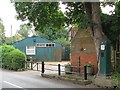
6
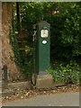
The old petrol pump, Oxton
Attached to the Old Forge, from which it was originally operated. Listed Grade II, the Listing describes it as a “Model AH 288 petrol pump, first manufactured by Avery Hardoll in December 1934.”
Image: © Alan Murray-Rust
Taken: 16 Jul 2020
0.10 miles
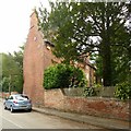
7
The Old Forge
A fine example of a typical village workshops complex, deriving from the original forge or smithy. The original forge building on the right dates from around 1800 and is Listed grade II.
Image: © Alan Murray-Rust
Taken: 18 Dec 2009
0.11 miles
8
The Old Forge
The main business today is clearly in timber, rather than metalwork, but the feel of a village workshops is retained. The petrol pump has the accolade of being Listed grade II, as is the brick forge building behind it.
Image: © Alan Murray-Rust
Taken: 18 Dec 2009
0.11 miles
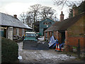
9
Former village garage, Oxton
This group of buildings used to be the village garage for Oxton, as demonstrated by the old petrol pump on the right.
Before that, it was the village blacksmith's forge, as shown by the tools still in place in the yard. To see some of his wheelwright's equipment, go to http://www.geograph.org.uk/photo/3081788 to see the bending machine and pit still in place in the yard.
Image: © Richard Green
Taken: 12 Aug 2012
0.12 miles
10
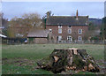
Home Farm House
This stands on the opposite side of Main Street to the former farmyard. This is the rear view from the Park. A typical Nottinghamshire farmhouse of the 18th century. Listed grade II.
Image: © Alan Murray-Rust
Taken: 18 Dec 2009
0.12 miles