IMAGES TAKEN NEAR TO
Kirklington Road, SOUTHWELL, NG25 0RU
Introduction
This page details the photographs taken nearby to Kirklington Road, NG25 0RU by members of the Geograph project.
The Geograph project started in 2005 with the aim of publishing, organising and preserving representative images for every square kilometre of Great Britain, Ireland and the Isle of Man.

There are currently over 7.5m images from over14,400 individuals and you can help contribute to the project by visiting https://www.geograph.org.uk
Image Map
Images are licensed for reuse under creativecommons.org/licenses/by-sa/2.0
Notes
- Clicking on the map will re-center to the selected point.
- The higher the marker number, the further away the image location is from the centre of the postcode.
Image Listing (16 Images Found)
Images are licensed for reuse under creativecommons.org/licenses/by-sa/2.0
Image
Details
Distance
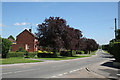
1
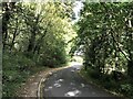
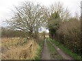
Southwell Urban Fringe
Exiting the town on foot via Kirklington Road.
Image: © Jonathan Clitheroe
Taken: 9 Oct 2020
0.07 miles
2
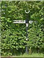
Fingerpost, Lower Kirklington Road/Kirklington Road, Southwell
Notts C C traditional cast-iron with annulus finial, rather enmeshed in the hedgerow.
Image: © Alan Murray-Rust
Taken: 1 Jun 2014
0.13 miles
4
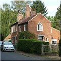
Pedlar's Cottage, 88 Kirklington Road, Southwell
Early 19th century cottage with Gothick windows, Listed Grade II. (The attached house is not part of the Listing)
Image: © Alan Murray-Rust
Taken: 13 Sep 2020
0.16 miles
6
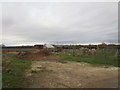
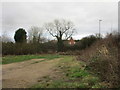
Allotments off Lower Kirklington Road
Image: © Jonathan Thacker
Taken: 5 Jan 2020
0.16 miles
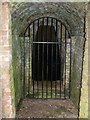
7
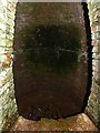
Ice house in Norwood Park ? 3
Built around the same time as the house, mid 18th century, restored in 1988.
The egg-shaped ice chamber, approx.6 metres high overall, see also http://www.geograph.org.uk/photo/6596600 and http://www.geograph.org.uk/photo/6596603
Image: © Alan Murray-Rust
Taken: 6 Sep 2020
0.19 miles
8
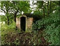
Ice house in Norwood Park ? 1
Built around the same time as the house, mid 18th century, restored in 1988.
Exterior view, see also http://www.geograph.org.uk/photo/6596603 and http://www.geograph.org.uk/photo/6596605
Image: © Alan Murray-Rust
Taken: 6 Sep 2020
0.20 miles
9
Ice house in Norwood Park ? 2
Built around the same time as the house, mid 18th century, restored in 1988. Entrance passageway, see also http://www.geograph.org.uk/photo/6596600 and http://www.geograph.org.uk/photo/6596605
Image: © Alan Murray-Rust
Taken: 6 Sep 2020
0.20 miles
10
Lower Kirklington Road
Showing part of the council housing development based on Norwood Gardens.
Image: © Alan Murray-Rust
Taken: 9 Jun 2008
0.21 miles