IMAGES TAKEN NEAR TO
Ollerton Road, SOUTHWELL, NG25 0RG
Introduction
This page details the photographs taken nearby to Ollerton Road, NG25 0RG by members of the Geograph project.
The Geograph project started in 2005 with the aim of publishing, organising and preserving representative images for every square kilometre of Great Britain, Ireland and the Isle of Man.

There are currently over 7.5m images from over14,400 individuals and you can help contribute to the project by visiting https://www.geograph.org.uk
Image Map
Images are licensed for reuse under creativecommons.org/licenses/by-sa/2.0
Notes
- Clicking on the map will re-center to the selected point.
- The higher the marker number, the further away the image location is from the centre of the postcode.
Image Listing (11 Images Found)
Images are licensed for reuse under creativecommons.org/licenses/by-sa/2.0
Image
Details
Distance
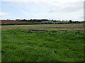
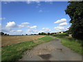
3
Looking down on Oxton Grange
The picture doesn't convey the strong smell of silage being blown up the hillside.
Image: © Alan Murray-Rust
Taken: 21 Jul 2020
0.07 miles
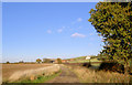
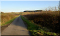
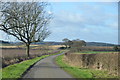
7
Greaves Lane
Near Oxton Grange.
The lane descends from Loath Hill to give a fine view ahead.
Image: © J.Hannan-Briggs
Taken: 30 Jan 2016
0.21 miles
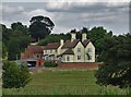
8
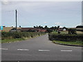
Oxton Grange Farm
from the A6097 Ollerton Road
Image: © Tom Courtney
Taken: 23 Aug 2005
0.21 miles
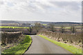
9
Greaves Lane towards Ollerton Road (A6097)
The junction is up ahead.
Image: © J.Hannan-Briggs
Taken: 30 Jan 2016
0.22 miles
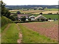
10
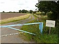
Track to Oxton Grange Farm
'No public right of way' is so much better than 'Keep out'!
Image: © Alan Murray-Rust
Taken: 21 Jul 2020
0.22 miles