IMAGES TAKEN NEAR TO
Upton Road, SOUTHWELL, NG25 0QA
Introduction
This page details the photographs taken nearby to Upton Road, NG25 0QA by members of the Geograph project.
The Geograph project started in 2005 with the aim of publishing, organising and preserving representative images for every square kilometre of Great Britain, Ireland and the Isle of Man.

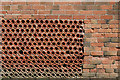
There are currently over 7.5m images from over14,400 individuals and you can help contribute to the project by visiting https://www.geograph.org.uk
Image Map
Images are licensed for reuse under creativecommons.org/licenses/by-sa/2.0
Notes
- Clicking on the map will re-center to the selected point.
- The higher the marker number, the further away the image location is from the centre of the postcode.
Image Listing (16 Images Found)
Images are licensed for reuse under creativecommons.org/licenses/by-sa/2.0
Image
Details
Distance
1
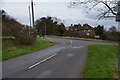
Normanton road junction with A617
Turning right takes you to Southwell.
Image: © Julian P Guffogg
Taken: 27 Jan 2016
0.08 miles
2
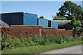
Wall on Galley Hill Road
This has been constructed using land drain pipes, in a dry construction with a few reinforcing piers.
Image: © Alan Murray-Rust
Taken: 9 Jun 2008
0.12 miles
3
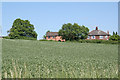
Galley Hill Road
Looking south across the valley of the River Greet
Image: © Alan Murray-Rust
Taken: 9 Jun 2008
0.12 miles
4
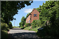
Towards Upton Field, Southwell, from Normanton Road
Image: © Chris
Taken: 23 Jun 2018
0.13 miles
5
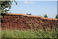
Wall of pipes
Field drainage pipes used to create a wall. An economic way of providing a wall. This section has been built with mortar, compare with Image
Image: © Alan Murray-Rust
Taken: 9 Jun 2008
0.13 miles
6
Beanfield
Looking across to Galley Hill Road
Image: © Alan Murray-Rust
Taken: 9 Jun 2008
0.14 miles
7
Dry-pipe walling
An effective use of earthenware field drain pipes to create a wall with relatively little effort. Compare with Image
Image: © Alan Murray-Rust
Taken: 9 Jun 2008
0.14 miles
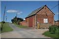
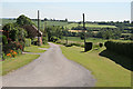
9
Galley Hill Road
Cul-de-sac marked as having public access.
Image: © Alan Murray-Rust
Taken: 9 Jun 2008
0.15 miles
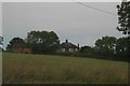
10
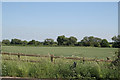
Cornfield alongside the River Greet
Viewed from Upton Road
Image: © Alan Murray-Rust
Taken: 9 Jun 2008
0.16 miles