IMAGES TAKEN NEAR TO
Halam Road, SOUTHWELL, NG25 0PQ
Introduction
This page details the photographs taken nearby to Halam Road, NG25 0PQ by members of the Geograph project.
The Geograph project started in 2005 with the aim of publishing, organising and preserving representative images for every square kilometre of Great Britain, Ireland and the Isle of Man.

There are currently over 7.5m images from over14,400 individuals and you can help contribute to the project by visiting https://www.geograph.org.uk
Image Map
Images are licensed for reuse under creativecommons.org/licenses/by-sa/2.0
Notes
- Clicking on the map will re-center to the selected point.
- The higher the marker number, the further away the image location is from the centre of the postcode.
Image Listing (10 Images Found)
Images are licensed for reuse under creativecommons.org/licenses/by-sa/2.0
Image
Details
Distance
1
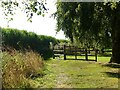
Robin Hood Way off Saversick Lane
The path is not separated from the grounds of the house called Halam Gate http://www.geograph.org.uk/photo/6970083 , except for this section. Until you get very close, the reason is not obvious, but is ensuring that walkers keep clear of the guy stays of an 11Kv electric transmission line pole. The path is part of the Robin Hood Way.
Image: © Alan Murray-Rust
Taken: 20 Sep 2021
0.08 miles
2
Robin Hood Way passing Halam Gate
The path runs between the hedge and the line of trees but is not fenced off from the grounds of the house.
Image: © Alan Murray-Rust
Taken: 20 Sep 2021
0.10 miles
3
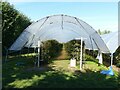
Polytunnel at Godber's Orchard
The crop in this instance is blackberries.
Image: © Alan Murray-Rust
Taken: 20 Sep 2021
0.11 miles
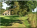
4
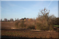
Farmland off Saversick Lane
View from Oxton Road towards Halam Gate with trees around a pond in the hollow
Image: © Richard Croft
Taken: 16 Jan 2012
0.12 miles
5
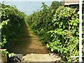
A tempting crop for passing walkers
Raspberry canes with ripe fruit in a polytunnel alongside the Robin Hood Way.
Image: © Alan Murray-Rust
Taken: 20 Sep 2021
0.14 miles
6
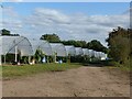
Polytunnels at Godber's Orchard
The track is a public footpath forming part of the Robin Hood Way.
Image: © Alan Murray-Rust
Taken: 20 Sep 2021
0.14 miles
7

The Garden Temple, Norwood Park
The temple in its setting in Norwood Park, see also http://www.geograph.org.uk/photo/6596576 .
Image: © Alan Murray-Rust
Taken: 6 Sep 2020
0.20 miles
8
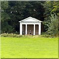
The Garden Temple, Norwood Park
Built in the late 18th century as a landscape feature in the parkland http://www.geograph.org.uk/photo/6596572 . Doric style front, Listed Grade II.
Image: © Alan Murray-Rust
Taken: 6 Sep 2020
0.20 miles
9
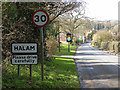
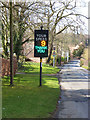
Eastern approach to Halam
Read-your-speed signs are common features in villages throughout the East Midlands. A car (behind camera) has just registered on this sign Image at the approach into Halam. See also Image
Image: © Oliver Dixon
Taken: 7 Mar 2014
0.21 miles
10
It's hard to break the speed limit when you're on a bike!
Read-your-speed signs are common features in villages throughout the East Midlands. This one is on the eastern approach into Halam.
Image: © Oliver Dixon
Taken: 7 Mar 2014
0.24 miles