IMAGES TAKEN NEAR TO
Hockerton Road, SOUTHWELL, NG25 0PP
Introduction
This page details the photographs taken nearby to Hockerton Road, NG25 0PP by members of the Geograph project.
The Geograph project started in 2005 with the aim of publishing, organising and preserving representative images for every square kilometre of Great Britain, Ireland and the Isle of Man.

There are currently over 7.5m images from over14,400 individuals and you can help contribute to the project by visiting https://www.geograph.org.uk
Image Map
Images are licensed for reuse under creativecommons.org/licenses/by-sa/2.0
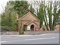
Notes
- Clicking on the map will re-center to the selected point.
- The higher the marker number, the further away the image location is from the centre of the postcode.
Image Listing (42 Images Found)
Images are licensed for reuse under creativecommons.org/licenses/by-sa/2.0
Image
Details
Distance
1
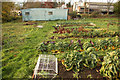
Organic vegetable garden
Veg garden at Hockerton Housing Project
Image: © Richard Croft
Taken: 17 Nov 2012
0.06 miles
2
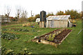
Organic vegetable garden
Vegetable garden at Hockerton Housing Project
Image: © Richard Croft
Taken: 17 Nov 2012
0.07 miles
3
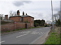
The Old Rectory, Hockerton
This turns its back on the main road, the busy A617 between Newark and Mansfield; the main front faces the church.
Image: © Alan Murray-Rust
Taken: 21 Apr 2013
0.07 miles
4
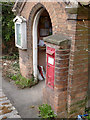
Hockerton/Southwell postbox NG25 96
VR wall box built into a projection from the porch of the former Methodist schoolroom, now the village hall.
Image: © Alan Murray-Rust
Taken: 21 Apr 2013
0.08 miles
5
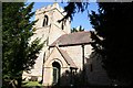
St.Nicholas' church, Hockerton
St.Nicholas' church has Norman origins, the upper part of the tower is 14th century, so the lower parts must be earlier.
Image: © Richard Croft
Taken: 10 Sep 2007
0.08 miles
6
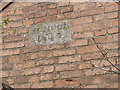
Datestone on Hockerton school
A delicately carved inscription with the date 1843. See http://www.geograph.org.uk/photo/3427043
Image: © Alan Murray-Rust
Taken: 21 Apr 2013
0.08 miles
7
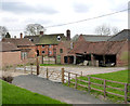
Manor Farm, Hockerton
The farmhouse has elements dating back to around 1600, with additions up to the 19th century. Originally timber framed, parts of which survive. Some blue-brick diaper-work is visible in this view (better at the higher resolution). Listed Grade II. To the right of the house can be seen the roof of an early 18th century threshing barn which is also Listed Grade II.
Image: © Alan Murray-Rust
Taken: 21 Apr 2013
0.09 miles
8
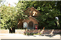
Methodist schoolroom
Former Methodist schoolroom at Hockerton, with a datestone of 1843
Image: © Richard Croft
Taken: 24 Jul 2012
0.09 miles
9
Former Methodist Schoolroom
Dating from 1843 and now used as the village hall.
Image: © Alan Murray-Rust
Taken: 21 Apr 2013
0.09 miles
10
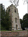
St.Nicholas's Church, Hockerton
The tower from the north-west. It dates principally from the 14th century although the base may be earlier.
There is a bench mark http://www.geograph.org.uk/photo/3429760 at the foot of the buttress.
Image: © Alan Murray-Rust
Taken: 21 Apr 2013
0.09 miles