IMAGES TAKEN NEAR TO
Caunton Road, SOUTHWELL, NG25 0PN
Introduction
This page details the photographs taken nearby to Caunton Road, NG25 0PN by members of the Geograph project.
The Geograph project started in 2005 with the aim of publishing, organising and preserving representative images for every square kilometre of Great Britain, Ireland and the Isle of Man.

There are currently over 7.5m images from over14,400 individuals and you can help contribute to the project by visiting https://www.geograph.org.uk
Image Map
Images are licensed for reuse under creativecommons.org/licenses/by-sa/2.0
Notes
- Clicking on the map will re-center to the selected point.
- The higher the marker number, the further away the image location is from the centre of the postcode.
Image Listing (8 Images Found)
Images are licensed for reuse under creativecommons.org/licenses/by-sa/2.0
Image
Details
Distance
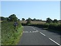
1
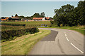
Newfields Farm
Hockerton Road and Newfields Farm
Image: © Richard Croft
Taken: 24 Jul 2012
0.04 miles
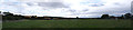
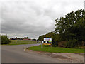
5
Newfield Farm
Viewed from the south, with Park Spring Wood in the background.
Image: © Jonathan Billinger
Taken: 29 May 2007
0.09 miles
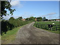
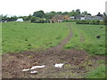
6
Entrance to Newfields dairy ice cream parlour and caf
Image: © Steve Fareham
Taken: 26 Aug 2014
0.13 miles
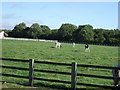
7
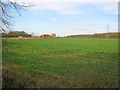
Newlands Farm
View north-west across a field of winter kale, with Park Spring Wood on the right. Newlands Farm has obviously been converted into a large modern house, with building work still going on.
Image: © Trevor Rickard
Taken: 26 Nov 2011
0.18 miles