IMAGES TAKEN NEAR TO
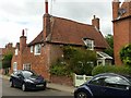
Westhorpe, SOUTHWELL, NG25 0NE
Introduction
This page details the photographs taken nearby to Westhorpe, NG25 0NE by members of the Geograph project.
The Geograph project started in 2005 with the aim of publishing, organising and preserving representative images for every square kilometre of Great Britain, Ireland and the Isle of Man.

There are currently over 7.5m images from over14,400 individuals and you can help contribute to the project by visiting https://www.geograph.org.uk
Image Map
Images are licensed for reuse under creativecommons.org/licenses/by-sa/2.0
Notes
- Clicking on the map will re-center to the selected point.
- The higher the marker number, the further away the image location is from the centre of the postcode.
Image Listing (83 Images Found)
Images are licensed for reuse under creativecommons.org/licenses/by-sa/2.0
Image
Details
Distance
1
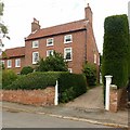
Westhorpe House, 54 Westhorpe, Southwell
Former farmhouse, c.1780, Listed Grade II.
Image: © Alan Murray-Rust
Taken: 26 Jul 2020
0.02 miles
2
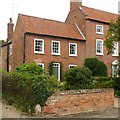
Stafford's Farm, Westhorpe
Former farmhouse, late 18th century, Listed Grade II.
Image: © Alan Murray-Rust
Taken: 26 Jul 2020
0.02 miles
3
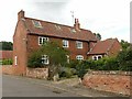
46, 48 & 50 Westhorpe, Southwell
Dating from the late 18th and early 19th century, Listed Grade II.
Image: © Alan Murray-Rust
Taken: 26 Jul 2020
0.03 miles
4
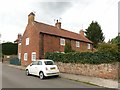
58 Westhorpe, Southwell
Former farmhouse, mid 18th century with later alterations and additions, Listed Grade II.
Image: © Alan Murray-Rust
Taken: 26 Jul 2020
0.03 miles
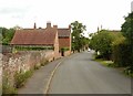
5
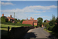
Westhorpe, Southwell
The old western end of the town, the road and the community share the same name.
Image: © Alan Murray-Rust
Taken: 19 Jun 2008
0.03 miles
6
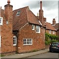
40 Westhorpe, Southwell
This is an aisled hall house of the early 17th century, timber framed with brick cladding. Listed Grade II together with no.42 to its left.
Image: © Alan Murray-Rust
Taken: 26 Jul 2020
0.04 miles
7
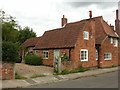
42 Westhorpe, Southwell
Early 19th century cottage attached to no.40 (with hipped roof), the two being Listed Grade II as a single entity. The rear range of outbuildings is separately Listed Grade II.
Image: © Alan Murray-Rust
Taken: 26 Jul 2020
0.04 miles
8
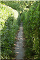
Footpath from Westhorpe
This path heads out towards open country and joins the Robin Hood Way
Image: © Alan Murray-Rust
Taken: 19 Jun 2008
0.04 miles
9
40 Westhorpe, Southwell
This is an aisled hall house of the early 17th century, timber framed with brick cladding. Listed Grade II together with no.42 to its left.
Image: © Alan Murray-Rust
Taken: 26 Jul 2020
0.04 miles
10
Westhorpe, Southwell
The 'thorpe' element of the name reflects the fact that this was a separate community attached to the main town of Southwell.
Image: © Alan Murray-Rust
Taken: 26 Jul 2020
0.04 miles