IMAGES TAKEN NEAR TO
Landseer Road, SOUTHWELL, NG25 0LZ
Introduction
This page details the photographs taken nearby to Landseer Road, NG25 0LZ by members of the Geograph project.
The Geograph project started in 2005 with the aim of publishing, organising and preserving representative images for every square kilometre of Great Britain, Ireland and the Isle of Man.

There are currently over 7.5m images from over14,400 individuals and you can help contribute to the project by visiting https://www.geograph.org.uk
Image Map
Images are licensed for reuse under creativecommons.org/licenses/by-sa/2.0
Notes
- Clicking on the map will re-center to the selected point.
- The higher the marker number, the further away the image location is from the centre of the postcode.
Image Listing (98 Images Found)
Images are licensed for reuse under creativecommons.org/licenses/by-sa/2.0
Image
Details
Distance
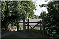
1
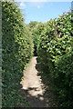
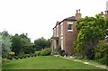
Footpath along the ridge
The footpath follows the ridge of the high ground to the west of Southwell Town Centre and acts as a divide between housing development on either side
Image: © Alan Murray-Rust
Taken: 19 Jun 2008
0.09 miles
2
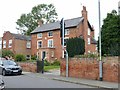
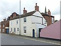
102 Westgate, Southwell - Honing House
Late 18th century house with top floor added in the early 19th and later additions, Listed Grade II.
The garden wall and gate are separately Listed Grade II.
Image: © Alan Murray-Rust
Taken: 30 Aug 2020
0.09 miles
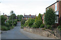
3
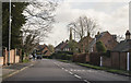
Westgate, Southwell
Holy Trinity church spire can be seen ahead.
Image: © J.Hannan-Briggs
Taken: 30 Jan 2016
0.10 miles
4
Ridge footpath looking west
At the top of Trinity Road. There is housing development on both side, but the footpath is uninterrupted for nearly 1 kilometre
Image: © Alan Murray-Rust
Taken: 19 Jun 2008
0.10 miles
5
The top of Trinity Road
The link from Trinity Road onto the footpath along the ridge
Image: © Alan Murray-Rust
Taken: 19 Jun 2008
0.10 miles
6
Halloughton Road
This forms a cut through from Nottingham Road to Westhorpe
Image: © Alan Murray-Rust
Taken: 19 Jun 2008
0.11 miles
7
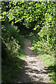
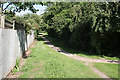
Woodland walk
In practice this footpath divides two areas of housing development on the hill to the west of Southwell town centre. This appears to be a boundary between different landowners, judged by the way development has taken place on either side of the footpath.
Image: © Alan Murray-Rust
Taken: 19 Jun 2008
0.11 miles
8
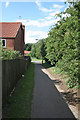
Footpath link to Beaumont Avenue
All the housing developments off either Halam Road or Westgate are linked to the spine footpath along the ridge of High Town.
Image: © Alan Murray-Rust
Taken: 19 Jun 2008
0.13 miles
9
81A Westgate, Southwell
Late 18th century, extended away from the road – the plain brick section behind - in 1824 http://www.geograph.org.uk/photo/6587206 , subsequently split to form two houses, Listed Grade II as a single Listing.
Image: © Alan Murray-Rust
Taken: 30 Aug 2020
0.13 miles
10
81 Westgate, Southwell
The early 19th century extension of no.81A http://www.geograph.org.uk/photo/6587203 , dated 1824. Regency style, Listed Grade II.
Image: © Alan Murray-Rust
Taken: 30 Aug 2020
0.14 miles