IMAGES TAKEN NEAR TO
Harveys Field, SOUTHWELL, NG25 0JD
Introduction
This page details the photographs taken nearby to Harveys Field, NG25 0JD by members of the Geograph project.
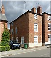
The Geograph project started in 2005 with the aim of publishing, organising and preserving representative images for every square kilometre of Great Britain, Ireland and the Isle of Man.

There are currently over 7.5m images from over14,400 individuals and you can help contribute to the project by visiting https://www.geograph.org.uk
Image Map
Images are licensed for reuse under creativecommons.org/licenses/by-sa/2.0
Notes
- Clicking on the map will re-center to the selected point.
- The higher the marker number, the further away the image location is from the centre of the postcode.
Image Listing (557 Images Found)
Images are licensed for reuse under creativecommons.org/licenses/by-sa/2.0
Image
Details
Distance
1
Southwell NG25, Notts.
Potwell Dyke Bridge and Bridge House on Church Street, Easthorpe are seen here from a footpath running parallel with the river. Walkers on this section of the Bramley Apple Trail - behind the photographer - may well have just crossed some nearby open playing fields that previously belonged to the Minster School. This early C19 bridge with its single arch is Grade II-listed.
Image: © David Hallam-Jones
Taken: 25 May 2013
0.03 miles
2
Potwell Dyke Bridge
This bridge is Grade II listed.
Image: © David Bremner
Taken: 2 Oct 2023
0.03 miles
3
Church Street crossing the Potwell Dyke, Southwell
Image: © Jonathan Thacker
Taken: 15 Dec 2021
0.04 miles
4
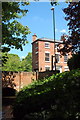
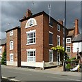
45 Church Street, Southwell
Late 18th century house, Listed Grade II. The slate roof is likely to be a later modification as the normal material at the time would have been pantiles.
Image: © Alan Murray-Rust
Taken: 30 Aug 2020
0.04 miles
5
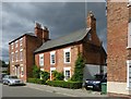
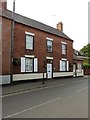
47 Church Street, Southwell
One of several houses built end-on to the street due to the narrow plots. Early 19th century, Listed Grade II.
Image: © Alan Murray-Rust
Taken: 30 Aug 2020
0.04 miles
6
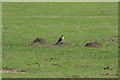
Thrush on a molehill
Thrushes have disappeared from my immediate locality at home, so it was nice to see this one in the district.
Image: © Alan Murray-Rust
Taken: 9 Jun 2008
0.04 miles
7
49 Church Street, Southwell
Late 18th century former farmhouse, built end-on due to the narrowness of the plot. Listed Grade II.
Image: © Alan Murray-Rust
Taken: 30 Aug 2020
0.04 miles
8
56 Church Street, Southwell
Early 19th century house, Listed Grade II.
Image: © Alan Murray-Rust
Taken: 13 Sep 2020
0.04 miles
9
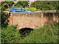
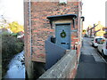
Potwell Dyke bridge, Church Street, Southwell
Early 19th century brick bridge, Listed Grade II.
Image: © Alan Murray-Rust
Taken: 30 Aug 2020
0.04 miles
10
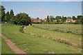
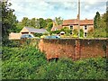
Potwell Dyke
Here the stream flows through an area of open space which used to be the playing fields of the Minster School, which has now relocated.
Image: © Alan Murray-Rust
Taken: 9 Jun 2008
0.04 miles