IMAGES TAKEN NEAR TO
Easthorpe, SOUTHWELL, NG25 0HZ
Introduction
This page details the photographs taken nearby to Easthorpe, NG25 0HZ by members of the Geograph project.
The Geograph project started in 2005 with the aim of publishing, organising and preserving representative images for every square kilometre of Great Britain, Ireland and the Isle of Man.

There are currently over 7.5m images from over14,400 individuals and you can help contribute to the project by visiting https://www.geograph.org.uk
Image Map
Images are licensed for reuse under creativecommons.org/licenses/by-sa/2.0
Notes
- Clicking on the map will re-center to the selected point.
- The higher the marker number, the further away the image location is from the centre of the postcode.
Image Listing (135 Images Found)
Images are licensed for reuse under creativecommons.org/licenses/by-sa/2.0
Image
Details
Distance
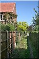
1
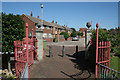
Entrance to Potwell Close
Looking back towards Easthorpe. A fine display of pineapple finials.
Image: © Alan Murray-Rust
Taken: 9 Jun 2008
0.01 miles
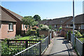
2
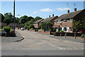
Cul-de-sac off Easthorpe
This cul-de-sac is deemed to be part of Easthorpe, the road which crosses in the foreground. The name applies equally to the road and the district, which clearly originally only included houses along the road itself.
Image: © Alan Murray-Rust
Taken: 9 Jun 2008
0.02 miles
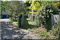
3
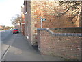
The entrance to the path leading to Crew Lane
Off Easthorpe.
Image: © Jonathan Thacker
Taken: 13 Jan 2012
0.02 miles
5
Footpath to Easthorpe
Southwell has an extensive network of what clearly used to be field paths which have survived in the urban development. This is part of the link from the old town centre to Easthorpe.
Image: © Alan Murray-Rust
Taken: 9 Jun 2008
0.04 miles
6

Potwell Close, Easthorpe, Southwell
Late 20th century development of sheltered accommodation, with pedestrian only access.
Image: © Alan Murray-Rust
Taken: 30 Aug 2020
0.04 miles
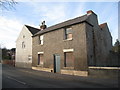
7
Buildings on Easthorpe
The central building looks as if it could have been a school, but there are no specific indications. The name Easthorpe applies to road and suburb.
Image: © Alan Murray-Rust
Taken: 9 Jun 2008
0.04 miles
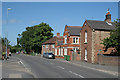
8
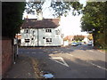
The Old Coach House
The Old Coach House pub in Southwell, located on a sharp bend in the A612.
Image: © Ajay Tegala
Taken: 12 Oct 2008
0.05 miles
9
Footpath to town
Southwell has an extensive network of what clearly used to be field paths which have survived in the urban development.
Image: © Alan Murray-Rust
Taken: 9 Jun 2008
0.06 miles
10
Potwell Close
This development of bungalows for the elderly takes its name from the nearby stream.
Image: © Alan Murray-Rust
Taken: 9 Jun 2008
0.06 miles