IMAGES TAKEN NEAR TO
Church Street, SOUTHWELL, NG25 0HQ
Introduction
This page details the photographs taken nearby to Church Street, NG25 0HQ by members of the Geograph project.
The Geograph project started in 2005 with the aim of publishing, organising and preserving representative images for every square kilometre of Great Britain, Ireland and the Isle of Man.

There are currently over 7.5m images from over14,400 individuals and you can help contribute to the project by visiting https://www.geograph.org.uk
Image Map
Images are licensed for reuse under creativecommons.org/licenses/by-sa/2.0
Notes
- Clicking on the map will re-center to the selected point.
- The higher the marker number, the further away the image location is from the centre of the postcode.
Image Listing (773 Images Found)
Images are licensed for reuse under creativecommons.org/licenses/by-sa/2.0
Image
Details
Distance
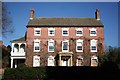
1
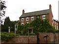
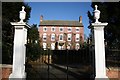
Normanton Prebend, Church Street, Southwell
One of the 9 remaining prebendary houses in Southwell, originally occupied by the canon holding the specific prebend, now a private residence. Built 1766, probably incorporating parts of an earlier house. Listed Grade II
Image: © Alan Murray-Rust
Taken: 30 Aug 2020
0.01 miles
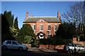
2
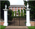
Normanton Prebend, Church Street, Southwell
A fine five-bay Georgian house built c1765. The windows have triple keystones and the house has a Tuscan porch, all set back behind tall panelled gatepiers topped with urns. Grade II listed.
Closer view: Image
Image: © Stephen Richards
Taken: 21 Jun 2012
0.01 miles
4
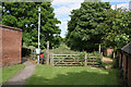
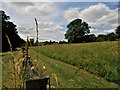
Footpath junction
The two footpaths signed here show completely opposite characteristics, despite being in the middle of an urban area. The left hand one is typically urban, fully surfaced, leading up to the commercial part of the town. The right hand one is entirely rural, running alongside hay meadows to the eastern part of the town, Easthorpe.
Image: © Alan Murray-Rust
Taken: 19 Jun 2008
0.02 miles
6
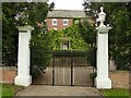
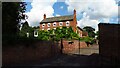
Gateway to the Normanton Prebend, Church Street, Southwell
Listed Grade II as part of the Listing of the house http://www.geograph.org.uk/photo/6591907 , probably of contemporary construction to it.
Image: © Alan Murray-Rust
Taken: 30 Aug 2020
0.03 miles
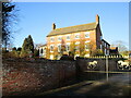
7
North Muskham Prebend
At its core is a 17th century house, added to in c1789 with the facade seen today added c1809, now home to a firm of solicitors.
Image: © Richard Croft
Taken: 7 Feb 2007
0.03 miles
8
Normanton Prebend, Southwell
Dates from about 1766 https://historicengland.org.uk/listing/the-list/list-entry/1211643?section=official-listing
Image: © Jonathan Thacker
Taken: 15 Dec 2021
0.03 miles
9
Froggatts Field Southwell
The tower of Southwell Minster can be seen in the distance. View from Froggatts Field (a gift to the town).
Image: © norman griffin
Taken: 26 Jun 2017
0.03 miles
10
Normanton Prebend
Large Prebend House at Southwell, five bays, three storeys and a central porch with Doric columns, c1765
Image: © Richard Croft
Taken: 7 Feb 2007
0.03 miles