
IMAGES TAKEN NEAR TO
Market Place, SOUTHWELL, NG25 0HE
Introduction
This page details the photographs taken nearby to Market Place, NG25 0HE by members of the Geograph project.
The Geograph project started in 2005 with the aim of publishing, organising and preserving representative images for every square kilometre of Great Britain, Ireland and the Isle of Man.

There are currently over 7.5m images from over14,400 individuals and you can help contribute to the project by visiting https://www.geograph.org.uk
Image Map
Images are licensed for reuse under creativecommons.org/licenses/by-sa/2.0
Notes
- Clicking on the map will re-center to the selected point.
- The higher the marker number, the further away the image location is from the centre of the postcode.
Image Listing (758 Images Found)
Images are licensed for reuse under creativecommons.org/licenses/by-sa/2.0
Image
Details
Distance
1
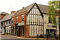
6 Market Place
Grade II listed early 16th century timber-framed building with late 18th century refronting. This view perfectly illustrates how medieval buildings can appear later to street frontage
Image: © Richard Croft
Taken: 12 May 2014
0.00 miles
2
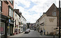
Southwell, King Street, after Francis Frith
Taken to show how Francis Frith's view from 1920 http://www.francisfrith.com/search/england/nottinghamshire/southwell/photos/southwell_69472.htm looks today.
The obvious change is the disappearance of the gabled building at the right of Frith's picture, which has been replaced by the car park of the Admiral Rodney pub. In the distance the Saracens Head now displays its timber framework which was plastered over on Frith's view.
Image: © Alan Murray-Rust
Taken: 19 Jun 2008
0.01 miles
3
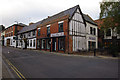
Market Place, Southwell
The shop, Violet Rose, appears to have been ""now open"" for over a year. It used to be a newsagent. The Saracens Head Hotel is beyond.
Compare with Image, taken in 2009.
Both shop and hotel are Listed Buildings - see https://historicengland.org.uk/listing/the-list/list-entry/1046101 & https://historicengland.org.uk/listing/the-list/list-entry/1369925 .
Image: © Ian Taylor
Taken: 27 Oct 2014
0.01 miles
4
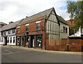
6 Market Place, Southwell
Early 16th century timber framed house with early 18th century rear wing and late 18th century brick front, later adapted for retail use, and retaining parts of an early 19th century shop front. Listed Grade II.
Image: © Alan Murray-Rust
Taken: 30 Aug 2020
0.01 miles
5
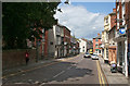
Westgate, after Francis Frith
Taken to show how Francis Frith's view from 1920 http://www.francisfrith.com/search/england/nottinghamshire/southwell/photos/southwell_69469.htm looks today.
The road surface has improved, but the buildings are little changed apart from modern signs.
Image: © Alan Murray-Rust
Taken: 19 Jun 2008
0.01 miles
6

Approaching the junction of Westgate and Queensgate
Image: © Basher Eyre
Taken: 3 Jun 2026
0.01 miles
7

Plaque in Westgate
Also see https://en.wikipedia.org/wiki/Charles_I%27s_journey_from_Oxford_to_the_Scottish_army_camp_near_Newark
Image: © Basher Eyre
Taken: 3 Jun 2026
0.01 miles
8
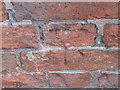
Ordnance Survey Cut Mark
This mark can be found on the wall of the Crown Hotel.
For more detail see : http://www.bench-marks.org.uk/bm45926
Image: © Peter Wood
Taken: 17 Oct 2012
0.01 miles
9
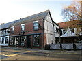
6 Market Place, Southwell
Dates from the sixteenth century https://historicengland.org.uk/listing/the-list/list-entry/1046101?section=official-listing
Image: © Jonathan Thacker
Taken: 15 Dec 2021
0.01 miles
10
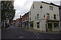
Queen Street, Southwell
The shop on the right and the two beyond (now a travel agent, bookshop and charity shop), are Grade II Listed Buildings - see https://historicengland.org.uk/listing/the-list/list-entry/1369899 & https://historicengland.org.uk/listing/the-list/list-entry/1046111 .
Image: © Ian Taylor
Taken: 27 Oct 2014
0.01 miles