IMAGES TAKEN NEAR TO
Church Street, SOUTHWELL, NG25 0HD
Introduction
This page details the photographs taken nearby to Church Street, NG25 0HD by members of the Geograph project.
The Geograph project started in 2005 with the aim of publishing, organising and preserving representative images for every square kilometre of Great Britain, Ireland and the Isle of Man.

There are currently over 7.5m images from over14,400 individuals and you can help contribute to the project by visiting https://www.geograph.org.uk
Image Map
Images are licensed for reuse under creativecommons.org/licenses/by-sa/2.0
Notes
- Clicking on the map will re-center to the selected point.
- The higher the marker number, the further away the image location is from the centre of the postcode.
Image Listing (742 Images Found)
Images are licensed for reuse under creativecommons.org/licenses/by-sa/2.0
Image
Details
Distance
1
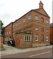
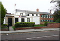
The old Collegiate Grammar School. Church Street, Southwell
Built 1819, now converted to office use, Listed Grade II.
Image: © Alan Murray-Rust
Taken: 30 Aug 2020
0.00 miles
2
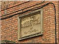
The old Collegiate Grammar School. Church Street, Southwell
Inscribed panel detail. See http://www.geograph.org.uk/photo/6591924 for location.
Image: © Alan Murray-Rust
Taken: 30 Aug 2020
0.00 miles
3
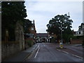
Church Street, Southwell next to the Minster
The small town of Southwell has much to offer the visitor, but nothing greater than the superb minster, one of Britain's lesser known treasures.
Image: © nick macneill
Taken: 19 Jul 2009
0.01 miles
4
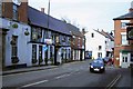
Saracens Head Hotel
Right on the road junction is this attractive building.
Image: © roger geach
Taken: 31 Jan 2009
0.01 miles
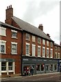
5
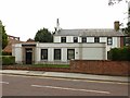
The National Westminster Bank branch, Church Street, Southwell
This was a house built c.1784 adjoining the prebendal house of Norwell Overhall to the right. The two storey bay window was added in the early 19C and the single storey extension in front in c.1920.
These buildings are listed Grade II; this description was taken from the listing details.
Image: © Humphrey Bolton
Taken: 25 Oct 2015
0.02 miles
6
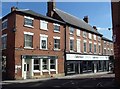
9 Church Street, Southwell
The house, to the rear, was built as an extension to the Norwell Overhall prebendal house adjacent http://www.geograph.org.uk/photo/6591928 in 1784. Sold to the Nottingham Banking Company in 1876 with the single storey banking hall added c.1920, operated as a bank, latterly National Westminster, until 2017. At the time of the visit in the process of conversion to residential use. Listed Grade II.
Image: © Alan Murray-Rust
Taken: 30 Aug 2020
0.02 miles
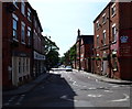
7
Junction of Church Street, Southwell
Looking across the end of Church Street in Southwell town centre.
Image: © Andrew Hill
Taken: 27 Sep 2013
0.02 miles
8
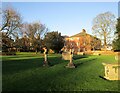
North-west corner of the churchyard, Southwell
Looking towards the rear of the Old Grammar School https://historicengland.org.uk/listing/the-list/list-entry/1046152?section=official-listing
Image: © Jonathan Thacker
Taken: 15 Dec 2021
0.02 miles
9
3 ? 7 Church Street, Southwell
Originally 3 houses, mid 18th century and, at the far end c.1870, later combined to form a single retails unit. Listed Grade II.
Image: © Alan Murray-Rust
Taken: 30 Aug 2020
0.02 miles
10
Southwell NG25, Notts.
The town centre end of Church Street is seen here from the entrance of the former coaching inn, The Saracen's Head. The Tourist Information Office and the Minster can both be accessed further down on the right and several High Street banks also have premises on this street.
Image: © David Hallam-Jones
Taken: 25 May 2013
0.02 miles