IMAGES TAKEN NEAR TO
Adams Row, SOUTHWELL, NG25 0FF
Introduction
This page details the photographs taken nearby to Adams Row, NG25 0FF by members of the Geograph project.
The Geograph project started in 2005 with the aim of publishing, organising and preserving representative images for every square kilometre of Great Britain, Ireland and the Isle of Man.

There are currently over 7.5m images from over14,400 individuals and you can help contribute to the project by visiting https://www.geograph.org.uk
Image Map
Images are licensed for reuse under creativecommons.org/licenses/by-sa/2.0
Notes
- Clicking on the map will re-center to the selected point.
- The higher the marker number, the further away the image location is from the centre of the postcode.
Image Listing (72 Images Found)
Images are licensed for reuse under creativecommons.org/licenses/by-sa/2.0
Image
Details
Distance
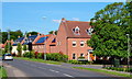
1

Humberstone Road
Small, modern housing estate off Halam Road, Southwell.
Image: © Ajay Tegala
Taken: 10 Dec 2008
0.07 miles
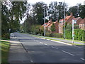
2
Kirklington Road in Southwell
Pictured from the spot where the road joins Queen Street on the right and Halam Road on the left.
Image: © Jonathan Clitheroe
Taken: 9 Oct 2020
0.07 miles
3
Norwood Villas
This building with its fake-stone stucco is completely out of place in the townscape. Its looks are not helped by the wide eaves which are not matched at the back, and the incongruity between the stucco and the plain brickwork of the end wall.
Image: © Alan Murray-Rust
Taken: 19 Jun 2008
0.08 miles
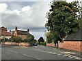
4
Former Sunday School, Kirklington Road, Southwell
Built c.1875, denomination unstated, converted to residential use late 20th century, Listed Grade II.
Image: © Alan Murray-Rust
Taken: 30 Aug 2020
0.08 miles
5
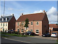
Southwell NG25, Notts.
The new-ish (c.2008) Merryweather Estate, off the Southwell-Halam road. This was a former location of the H. Merryweather & Sons Nursery and it was here that the famous Bramley apple was first cultivated. This is the Humberstone Road turning. The village of Halam lies in the distance, further westwards.
Image: © David Hallam-Jones
Taken: 25 May 2013
0.08 miles
6
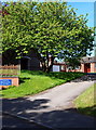
Southwell NG25, Notts.
The driveway to the presbytery of "Our Lady of Victories" Roman Catholic Church, Wolsey Close, off Halam Road. The church's name is a dedication to the Blessed Virgin Mary and also commemorates the Battle of Lepanto. Halam Road, a "C" road linking Southwell and Halam, lies to the right.
Image: © David Hallam-Jones
Taken: 25 May 2013
0.08 miles
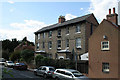
8
1 Kirklington Road, Southwell
Late 18th century house, Listed Grade II, the Listing includes the boundary wall.
Image: © Alan Murray-Rust
Taken: 30 Aug 2020
0.10 miles
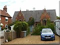
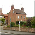
9
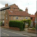
2 Halam Road, Southwell
Mid 18th century cottage, unusually for Southwell stone- rather than brick-built, extended towards the road at some stage, Listed Grade II. Boundary wall included in the Listing.
Image: © Alan Murray-Rust
Taken: 30 Aug 2020
0.10 miles