IMAGES TAKEN NEAR TO
Private Road, SOUTHWELL, NG25 0EJ
Introduction
This page details the photographs taken nearby to Private Road, NG25 0EJ by members of the Geograph project.
The Geograph project started in 2005 with the aim of publishing, organising and preserving representative images for every square kilometre of Great Britain, Ireland and the Isle of Man.

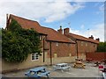
There are currently over 7.5m images from over14,400 individuals and you can help contribute to the project by visiting https://www.geograph.org.uk
Image Map
Images are licensed for reuse under creativecommons.org/licenses/by-sa/2.0
Notes
- Clicking on the map will re-center to the selected point.
- The higher the marker number, the further away the image location is from the centre of the postcode.
Image Listing (639 Images Found)
Images are licensed for reuse under creativecommons.org/licenses/by-sa/2.0
Image
Details
Distance
2
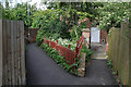
Entrance to the Women's Institute
The building heavily camouflaged behind Elder and Hawthorn. To the left one of the web of footpaths that characterise the town.
Image: © Alan Murray-Rust
Taken: 19 Jun 2008
0.03 miles
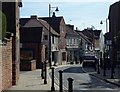
3
The Ropewalk
From Queen Street junction. The bus from Nottingham is making its way towards Norwood Gardens terminus.
Image: © Alan Murray-Rust
Taken: 19 Jun 2008
0.03 miles
4
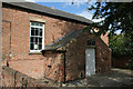
Women's Institute
This appears to be a converted chapel; there is a datestone over the door dated 1853.
Image: © Alan Murray-Rust
Taken: 19 Jun 2008
0.04 miles
5
4 Sheppard's Row, Southwell
No.4 comprises the two nearer section of the row, originally three cottages, now one dwelling. Late 18th and early 19th century, Listed Grade II. This is the rear view across the Admiral Rodney car park.
Image: © Alan Murray-Rust
Taken: 30 Aug 2020
0.04 miles
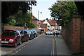
6
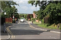
Queen Street, Southwell
Looking towards the town centre, a one-way street heading out of town. View near a grid square intersection.
Image: © Andrew Hill
Taken: 27 Sep 2013
0.05 miles
7
Queen Street
From The Ropewalk junction
Image: © Alan Murray-Rust
Taken: 19 Jun 2008
0.06 miles
8
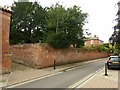
Boundary wall to Hardwick House, Queen Street, Southwell
Early 19th century, Listed Grade II. See also http://www.geograph.org.uk/photo/6589577
Image: © Alan Murray-Rust
Taken: 30 Aug 2020
0.06 miles
9
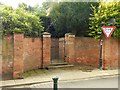
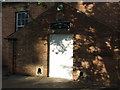
Gateway to Hardwick House, Queen Street, Southwell
Early 19th century, Listed Grade II. See also http://www.geograph.org.uk/photo/6589570
Image: © Alan Murray-Rust
Taken: 30 Aug 2020
0.06 miles
10
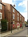
Southwell Post Office and adjacent shop,11 ? 15 Queen Street
Originally three houses, early 19th century. The building has served as Post Office since at least the 1930s, with a nice example of a large GVIR type A wall box http://www.geograph.org.uk/photo/6589563 and a pair of old stamp vending machines http://www.geograph.org.uk/photo/6589567 . Listed Grade II as a unit.
Image: © Alan Murray-Rust
Taken: 30 Aug 2020
0.06 miles