IMAGES TAKEN NEAR TO
Beaumont Avenue, SOUTHWELL, NG25 0BB
Introduction
This page details the photographs taken nearby to Beaumont Avenue, NG25 0BB by members of the Geograph project.
The Geograph project started in 2005 with the aim of publishing, organising and preserving representative images for every square kilometre of Great Britain, Ireland and the Isle of Man.

There are currently over 7.5m images from over14,400 individuals and you can help contribute to the project by visiting https://www.geograph.org.uk
Image Map
Images are licensed for reuse under creativecommons.org/licenses/by-sa/2.0
Notes
- Clicking on the map will re-center to the selected point.
- The higher the marker number, the further away the image location is from the centre of the postcode.
Image Listing (52 Images Found)
Images are licensed for reuse under creativecommons.org/licenses/by-sa/2.0
Image
Details
Distance
1
Footpath to Halam Road
The hedge to the right marks the edge of housing development between the ridge and Halam Road.
Image: © Alan Murray-Rust
Taken: 19 Jun 2008
0.04 miles
2
May Hill
Part of a new development on the north side of the hill labelled High Town on the 1:25000. View northward towards Sherwood Forest.
Image: © Alan Murray-Rust
Taken: 19 Jun 2008
0.04 miles
3
Footpath link to Beaumont Avenue
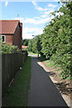
All the housing developments off either Halam Road or Westgate are linked to the spine footpath along the ridge of High Town.
Image: © Alan Murray-Rust
Taken: 19 Jun 2008
0.05 miles
4
The top of Trinity Road
The link from Trinity Road onto the footpath along the ridge
Image: © Alan Murray-Rust
Taken: 19 Jun 2008
0.06 miles
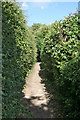
5
Ridge footpath looking west
At the top of Trinity Road. There is housing development on both side, but the footpath is uninterrupted for nearly 1 kilometre
Image: © Alan Murray-Rust
Taken: 19 Jun 2008
0.06 miles
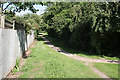
6
Footpath along the ridge
The footpath follows the ridge of the high ground to the west of Southwell Town Centre and acts as a divide between housing development on either side
Image: © Alan Murray-Rust
Taken: 19 Jun 2008
0.07 miles
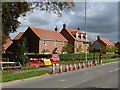
7
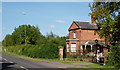
Southwell NG25, Notts.
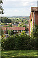
The Lodge House (or former Lodge House) on Halam Road, at the High Town end of the Norwood Park country estate. Behind the boundary hedge and beyond the lodge is the H. Merryweather & Sons Fruit Farm. Halam Road continues westwards, to the left, towards the village of Halam. Norwood Hall is the home of the Starkey family, whilst some of the ancillary buildings have been converted into function venues ("Norwood Park" venue/s).
Image: © David Hallam-Jones
Taken: 25 May 2013
0.07 miles
8
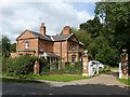
Lodge and gates to Norwood Park, Halam Road, Southwell
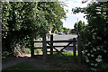
A substantial building, built c.1764, the architecture reflecting that of the main house http://www.geograph.org.uk/photo/6596258 , Listed Grade II.
The gateway with its flanking railings, rather overgrown, is separately Listed Grade II. The gates are mid 19th century.
Image: © Alan Murray-Rust
Taken: 6 Sep 2020
0.08 miles
9
The end of Hopkiln Lane, Southwell
Closed during flood alleviation scheme works. The housing is early 21st century new development.
Image: © Alan Murray-Rust
Taken: 6 Sep 2020
0.08 miles
10
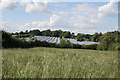
Wheatfield with polytunnels
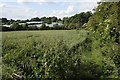
The crop in the foreground is wheat, but it has been heavily invaded by other grass varieties.
Image: © Alan Murray-Rust
Taken: 19 Jun 2008
0.09 miles