IMAGES TAKEN NEAR TO
London Road, NOTTINGHAM, NG2 4UU
Introduction
This page details the photographs taken nearby to London Road, NG2 4UU by members of the Geograph project.
The Geograph project started in 2005 with the aim of publishing, organising and preserving representative images for every square kilometre of Great Britain, Ireland and the Isle of Man.

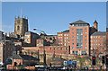
There are currently over 7.5m images from over14,400 individuals and you can help contribute to the project by visiting https://www.geograph.org.uk
Image Map
Images are licensed for reuse under creativecommons.org/licenses/by-sa/2.0
Notes
- Clicking on the map will re-center to the selected point.
- The higher the marker number, the further away the image location is from the centre of the postcode.
Image Listing (809 Images Found)
Images are licensed for reuse under creativecommons.org/licenses/by-sa/2.0
Image
Details
Distance
1
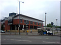
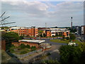
Auntie Beeb's Nottingham Premises
The Nottingham branch of the British Broadcasting Corporation on London Road.
Image: © James Hill
Taken: 6 Jun 2007
0.01 miles
2
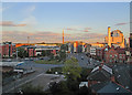
South-east from the Lace Market on a summer evening
A wider view than Image], taken a few moments later. The BBC Nottingham building is to the left of the roundabout and the setting sun catches the orange brickwork of the ruined Great Northern Railway goods warehouse beyond.
Image: © John Sutton
Taken: 3 Jun 2015
0.03 miles
3
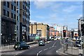
London Road, Nottingham
Taken from east of the railway station.
Image: © Trevor Harris
Taken: 20 Mar 2019
0.03 miles
4
BBC Island
As named on Open Street Map.
The chimney belongs to the electric generating station which uses steam from the city's refuse incinerator. The plant started life as a power station for the Boots Company's works.
Image: © Alan Murray-Rust
Taken: 23 Sep 2022
0.04 miles
5
Lace Market from London Road
St Mary's Church is the parish church of the City of Nottingham.
Image: © Alan Murray-Rust
Taken: 21 Jan 2007
0.04 miles
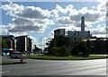
6
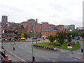
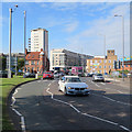
London Road Roundabout
London Road Roundabout and the surrounding area seen from an elevated position.
Image: © James Hill
Taken: 24 May 2007
0.04 miles
7
London Island and the BBC from the back of Lace Market House, High Pavement
This view shows London Island, off London Road with the BBC building amongst a cluster of early new-builds on the edge of a development site known as Eastside. After a number of false starts (most recently in 2011 a supermarket application) Eastside remains undeveloped since the site was disposed of many years ago by Boots.
Image: © Andrew Abbott
Taken: 12 Jun 2010
0.04 miles
8
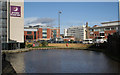
Nottingham Canal, Nottingham
Winding hole near Nottingham Station. Modern office and industrial development has replaced the former City site of the Boots Company.
Image: © Alan Murray-Rust
Taken: 21 Jan 2007
0.05 miles
9
Morning traffic
This is the big roundabout where London Road, Canal Street and Parliament Street meet. In the background is the Nottingham One housing development (with tower) built on former industrial and railway land between Canal Street and the canal.
Image: © John Sutton
Taken: 31 Aug 2017
0.05 miles
10
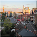
Lace Market to London Road
A view from the top of the sandstone bluff on a June evening. The houses of Cliff Road in Narrow Marsh are in the foreground, the big roundabout at the junction of Parliament Street, Canal Street and London Road in the middle distance to the left of centre, and Eastcroft Incinerator chimney is on the extreme left, beyond the Premier Inn at the top of London Road.
Image: © John Sutton
Taken: 3 Jun 2015
0.05 miles