IMAGES TAKEN NEAR TO
Millers Green, NOTTINGHAM, NG2 4NN
Introduction
This page details the photographs taken nearby to Millers Green, NG2 4NN by members of the Geograph project.
The Geograph project started in 2005 with the aim of publishing, organising and preserving representative images for every square kilometre of Great Britain, Ireland and the Isle of Man.

There are currently over 7.5m images from over14,400 individuals and you can help contribute to the project by visiting https://www.geograph.org.uk
Image Map
Images are licensed for reuse under creativecommons.org/licenses/by-sa/2.0
Notes
- Clicking on the map will re-center to the selected point.
- The higher the marker number, the further away the image location is from the centre of the postcode.
Image Listing (94 Images Found)
Images are licensed for reuse under creativecommons.org/licenses/by-sa/2.0
Image
Details
Distance
1
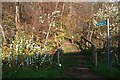
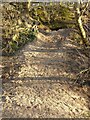
Steps on the path through Roughhill Wood
A steep climb up from Colwick Road on a path which skirts Roughhill wood to meet Sneinton Boulevard.
Image: © David Lally
Taken: 30 Nov 2009
0.02 miles
2
Colwick Road: where the Nottingham Suburban Railway once crossed
The Nottingham Suburban Railway (1889-1951) once crossed high above Colwick Road on a blue-brick arched bridge. The tree in the foreground is where the north abutment was; the footpath to Sneinton Boulevard climbs up where the embankment once was to a partly-filled cutting (see Image]) through the steep hillside.
Image: © John Sutton
Taken: 20 Apr 2012
0.02 miles
4
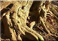
Knurly roots, Colwick Woods Park ? 2
The steep hillside means that tree roots are easily exposed.
Image: © Alan Murray-Rust
Taken: 25 Dec 2020
0.05 miles
5
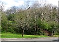
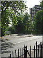
Colwick Road and Colwick Woods Court
Just the other side of the trees in the centre of the picture is the old bus terminus described here Image
Image: © David Lally
Taken: 30 Nov 2009
0.05 miles
6
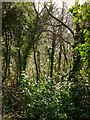
In Roughill Wood, Christmas Day 2020 ? 3
All the green stuff is ivy, the shiny leaves reflecting the sunlight.
Image: © Alan Murray-Rust
Taken: 25 Dec 2020
0.06 miles
7
Excavation, Colwick Woods Park
Here the underlying stratum is the soft yellow sandstone of the Sherwood group, probably excavated by foxes rather than badger (the location is a bit too public for the latter).
Image: © Alan Murray-Rust
Taken: 25 Dec 2020
0.07 miles
8
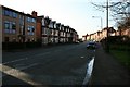
Colwick Road bus terminus
Until the late 1970s, City Transport buses terminated at this point, which had been the City boundary. The turnround was built when trolleybuses replaced the trams, which had also run to this point, in the mid 1930s.
Beyond this point services were provided by the Trent Motor Traction Company (today's Trent-Barton), but they were not allowed to carry local passengers inside the City area. Changes in regulations, followed by complete deregulation, meant a complete restructuring of services and a terminus at this location became superfluous. It has not now been used for more than 20 years.
Image: © Alan Murray-Rust
Taken: 20 Jun 2008
0.07 miles
9
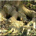
Knurly roots, Colwick Woods Park ? 1
The steep hillside means that tree roots are easily exposed.
Image: © Alan Murray-Rust
Taken: 25 Dec 2020
0.08 miles
10
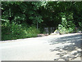
Kissing gate into Colwick Woods
Next to the Colwick Road level crossing
Image: © Alan Murray-Rust
Taken: 20 Jun 2008
0.08 miles