IMAGES TAKEN NEAR TO
Little Tennis Street, NOTTINGHAM, NG2 4EL
Introduction
This page details the photographs taken nearby to Little Tennis Street, NG2 4EL by members of the Geograph project.
The Geograph project started in 2005 with the aim of publishing, organising and preserving representative images for every square kilometre of Great Britain, Ireland and the Isle of Man.

There are currently over 7.5m images from over14,400 individuals and you can help contribute to the project by visiting https://www.geograph.org.uk
Image Map (Loading...)


Getting Data...Please wait
Leaflet Map data © OpenStreetMap
Images are licensed for reuse under creativecommons.org/licenses/by-sa/2.0
Notes
- Clicking on the map will re-center to the selected point.
- The higher the marker number, the further away the image location is from the centre of the postcode.
Image Listing (79 Images Found)
Images are licensed for reuse under creativecommons.org/licenses/by-sa/2.0
Image
Details
Distance
1
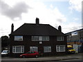
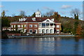
Pump Station House, Daleside Road
I have no idea why these houses, which look like typically 50s/60s semis, should be so named: a name that sounds as though it should be attached to a Victorian or Edwardian building. The houses look a little forlorn, standing as they do on a very busy road surrounded on all sides by industry.
Image: © Oxymoron
Taken: 3 Sep 2008
0.14 miles
2
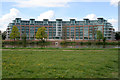
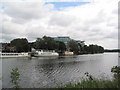
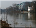
River Crescent, Trent Park
On the opposite bank of the River Trent to Lady Bay this massive £40,000,000 development of luxury apartments is Trent Park Development's flagship for sustainable development with wind turbines on the roof, solar reflective glazing and river source heat pumps. This is the first stage of the Nottingham Regeneration Limited's Waterside scheme which will see riverside homes, leisure facilities, business areas and shopping created from a run down industrial area over the next 10+ years. This style of living comes at a price though; the Penthouse apartments are over a million pounds!
See http://www.nottinghamregeneration.ltd.uk/default.htm for more information about NRL's city wide plan
Image: © Kate Jewell
Taken: 1 May 2008
0.15 miles
3
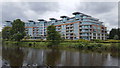
River Crescent
Exclusive private housing apartments beside the River Trent.
Image: © Peter Mackenzie
Taken: 18 Jun 2019
0.16 miles
4
River Crest Apartments next to the Trent
Viewed from the Trent Valley Way on the opposite bank.
Image: © Mat Fascione
Taken: 12 Mar 2016
0.16 miles
5
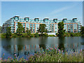
Approaching the River Crescent apartments
The newly-built 'prestigious luxury riverside apartments' of River Crescent are the start of large-scale redevelopment of the north bank of the Trent. I wonder what it will all look like 20 years from now.
Image: © Tim Heaton
Taken: 29 Jun 2008
0.16 miles
6
Waterside Way
Waterside Way apartments at Trent Park, with views over the River Trent
Image: © Richard Croft
Taken: 15 Jul 2011
0.17 miles
7
Trent Field and River Crescent Apartments
The River Trent is hidden between the field and the apartments. Several weeks with high temperatures and low rainfall is taking its toll on the vegetation.
Image: © Jonathan Thacker
Taken: 9 Jul 2018
0.17 miles
9
Rufford Hall along the River Trent
And the River Crest Apartments, both along Waterside Way.
Image: © Mat Fascione
Taken: 12 Mar 2016
0.17 miles
10
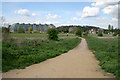
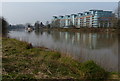
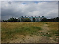
Trent Fields
Between Holme Road, Lady Bay and the River Trent this large area of statutory washlands stretches from Lady Bay Bridge in the west to Adbolton Lane in the East. Also known as The Hook, this meadowland provides a habitat for wildlife and a recreational area for local residents. It floods dramatically every 5 to 10 years, so will never be developed. The large building in the distance is a new luxury apartment development on the opposite bank of the River Trent.
Image: © Kate Jewell
Taken: 1 May 2008
0.17 miles