IMAGES TAKEN NEAR TO
Portside Street, NOTTINGHAM, NG2 4DN
Introduction
This page details the photographs taken nearby to Portside Street, NG2 4DN by members of the Geograph project.
The Geograph project started in 2005 with the aim of publishing, organising and preserving representative images for every square kilometre of Great Britain, Ireland and the Isle of Man.

There are currently over 7.5m images from over14,400 individuals and you can help contribute to the project by visiting https://www.geograph.org.uk
Image Map
Images are licensed for reuse under creativecommons.org/licenses/by-sa/2.0
Notes
- Clicking on the map will re-center to the selected point.
- The higher the marker number, the further away the image location is from the centre of the postcode.
Image Listing (102 Images Found)
Images are licensed for reuse under creativecommons.org/licenses/by-sa/2.0
Image
Details
Distance
1
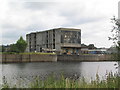
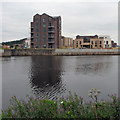
British Waterways warehouse by entrance to Trent Basin
An adjacent building, of equal ugliness, has the date '1930'. This area is destined to be completely 'regenerated', see http://www.trentbasin.co.uk/
Image: © Tim Heaton
Taken: 29 Jun 2008
0.01 miles
2
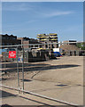
Trent Basin building site
A view through the Trent Lane fence. Homes are being built on the site of riverside warehouses which had been derelict for many years.
Image: © John Sutton
Taken: 16 May 2016
0.01 miles
4
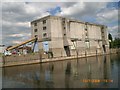
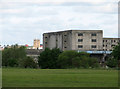
Nottingham Corporation Warehouse
Ownership is proclaimed in moulded letters along the roof parapet, with the building date, 1930, on each hoist. Along with the Cambridge Travelodge http://www.geograph.org.uk/photo/1778052 this must be a contender in any Ugliest Building in Britain contest....
Image: © John Sutton
Taken: 13 Aug 2009
0.02 miles
5
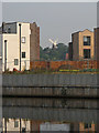
New housing and Green's Windmill
A telephoto shot across the Trent, with some of the as yet incomplete new homes at Trent Basin framing Green's Windmill in Sneinton. For a wider view, see Image
Image: © John Sutton
Taken: 8 Sep 2016
0.02 miles
6
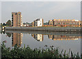
Trent Basin nearer completion
New homes on the site of riverside warehouses. St Stephen's Church and Green's Windmill in the centre of Sneinton show between the new blocks.
Earlier views:
Image] (August 2009)
Image] (May 2013)
Image] (April 2016)
Image] (May 2016)
Image: © John Sutton
Taken: 8 Sep 2016
0.02 miles
7
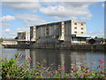
Disused industrial riverside River Trent at Nottingham
Image: © David Colyer
Taken: 13 Jul 2008
0.02 miles
8
Beauty and the beast
A zoom view across the meadows south of the Trent known as the Hook, showing the distant tower of St Mary's Church, on High Pavement in The Lace Market, and the hideous concrete Nottingham Corporation warehouse (seen from just across the river in Image] and other photos).
Image: © John Sutton
Taken: 20 May 2011
0.03 miles
9
New homes at Trent Basin
For comparison, see Image] (April 2016).
Image: © John Sutton
Taken: 14 Aug 2016
0.03 miles
10
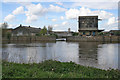
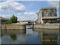
Industrial area, River Trent
This shabby, rundown industrial area is due for a massive regeneration programme including residential, leisure, retail and modern industry. This shows the entrance to a small basin alongside an old wood yard.
Image: © Kate Jewell
Taken: 1 May 2008
0.03 miles