IMAGES TAKEN NEAR TO
Hutton Street, NOTTINGHAM, NG2 4DD
Introduction
This page details the photographs taken nearby to Hutton Street, NG2 4DD by members of the Geograph project.
The Geograph project started in 2005 with the aim of publishing, organising and preserving representative images for every square kilometre of Great Britain, Ireland and the Isle of Man.

There are currently over 7.5m images from over14,400 individuals and you can help contribute to the project by visiting https://www.geograph.org.uk
Image Map
Images are licensed for reuse under creativecommons.org/licenses/by-sa/2.0
Notes
- Clicking on the map will re-center to the selected point.
- The higher the marker number, the further away the image location is from the centre of the postcode.
Image Listing (129 Images Found)
Images are licensed for reuse under creativecommons.org/licenses/by-sa/2.0
Image
Details
Distance
1
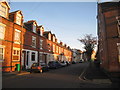
Sneinton: Trent Lane
Looking north from the pedestrian crossing over the railway. Typical late 19th-century houses, with some 20th-century infill.
Image: © John Sutton
Taken: 15 Apr 2011
0.02 miles
2

Trent Lane and a crane
The foot crossing is being replaced by a footbridge as part of the resignalling and reconfiguration of Nottingham Midland Station and its approaches. The abutments of the old Great Northern Railway bridge, which once carried the Nottingham to Grantham line over the Midland Lincoln line, are being recycled as the base of the new bridge.
Image] (April 2011) shows how things were, and relates more railway history.
Image: © John Sutton
Taken: 23 Jun 2013
0.03 miles
3
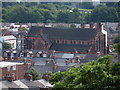
A new view of Sneinton
A view from the new railway footbridge at Trent Lane, with St Stephen's Church on the skyline to the left and Green's Windmill above the trees on the right.
Image: © John Sutton
Taken: 22 Aug 2013
0.04 miles
4
Trent Lane and the new footbridge
As part of the reconfiguration and resignalling of Nottingham Midland Station, the foot crossing at Trent Lane has been replaced by a footbridge, completed in August 2013. Image] and Image] are closer views of the new bridge.
Image: © John Sutton
Taken: 22 Aug 2013
0.05 miles
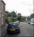
6
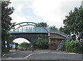
The new footbridge at Trent Lane
The footbridge is supported by the abutments of the former Great Northern Railway bridge. The blue-brick Nottingham Suburban Railway bridge over Trent Lane forms the backdrop. For more about the three railway lines at Trent Lane, see Image Image] shows the footbridge under construction.
Image: © John Sutton
Taken: 22 Aug 2013
0.06 miles
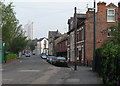
7

St Christopher's Church at Colwick Road / Trent Road junction
Ordnance Survey documents indicate that a benchmark was levelled in 1962 at 26.252m above Newlyn Datum on the corner of the wall, and verified in 1985
Image: © Roger Templeman
Taken: 28 Jan 2022
0.06 miles
8
St. Christopher's Church, Sneinton
Taken from Green's Mill
Image: © Andrew Abbott
Taken: 2 Aug 2008
0.06 miles
9
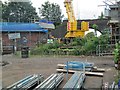
Footbridge building at Trent Lane
The foot crossing is being replaced by a footbridge as part of the resignalling and reconfiguration of Nottingham Midland Station and its approaches. The abutments of the old Great Northern Railway bridge, which once carried the Nottingham to Grantham line over the Midland Lincoln line, are being recycled as the base of the new bridge.
Image] (April 2011) shows how things were, and relates more railway history.
Image: © John Sutton
Taken: 23 Jun 2013
0.06 miles